
Red Rock Canyon National Conservation Area, Nevada - May 11th to 14th, 2024

Red Rock Canyon National Conservation Area is just outside Vegas in Nevada. We’re not big fans of Vegas, since we’re not gamblers or into the nightlife scene. However, we’ve heard and seen good things about the beautiful scenery and nature at Red Rock Canyon. Now that is more our scene.

Saturday was a travel day, from Coral Pink Sand Dunes State Park in Utah to Red Rock Canyon National Conservation Area in Nevada. Google Maps directed us south, dipping into Arizona, then headed over to I-15. This avoided us driving through Zion National Park and Springdale. Although the Zion route may have been more scenic, the traffic through there is always bad. Plus, there is the Zion-Mount Carmel Tunnel. Red Tail is close to the size restrictions, so we may have had to purchase a $15 permit and have them shut down the tunnel to one way traffic as we drove through. Red Tail is 11’1” tall which is under the non-permit max height of 11’4”, but it depends on how you measure the width. The limit is 7’10”. Red Tail is 8’2” with our mirrors extended, but only 6’11” wide with the mirrors folded in. We would be comfortable going through the tunnel with our mirrors folded in, especially since we know have the rear facing camera, but the officials at the tunnel may not agree with us.

Along the way to Red Rock Canyon, we took care of a lot of chores on our todo list. In Colorado City, Arizona, we stopped for gas. Right next door was Bee’s Market. It looked like a good sized grocery store, so we went in for our supplies. The store did not appear to be part of a large chain, but, as far as size and selection, it was on par with Kroger and Safeway stores.

We stopped at a Tractor Supply in Hurricane Valley, Utah, to top off one of our propane tanks. However, they were out of propane. So we tried again at a Tractor Supply in Mesquite, just across the border in Nevada. That time we were successful. Also in Mesquite, we visited the North View Laundromat. We were concerned it would be pretty busy on a Saturday, but we were pleasantly surprised. We washed, dried, folded, and stored away our two large loads of laundry in about an hour and a half. While the machines were running, we ate our lunch in Red Tail and downloaded some material while we had good cell service. All in all, it was a pretty efficient stop.

Our last stop was at a Love’s truck stop just as we approached Las Vegas. After filling up our gas, Keith wanted to weigh Red Tail again, so we swung around the back to the Cat Scale. By his calculations, we could fill up our fresh water tank to 95% with both propane tanks full and a full tank of gas, and still be under our GVWR (Gross Vehicle Weight Rating).

The scenery along the drive was not as spectacular as the other travel days so far this season, except for maybe the Virgin River Canyon. I-15 cuts through a small corner of Arizona, through the canyon cut by the Virgin River. It is a beautiful little stretch of interstate.

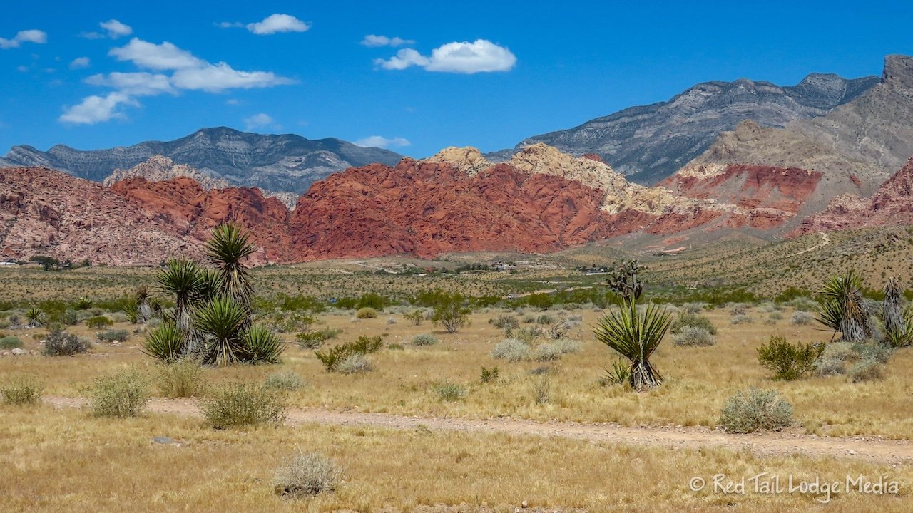
Red Rock Canyon is surprisingly close to Las Vegas. The campground is just a mile or two from the edge of the city. The Red Rock Canyon Scenic Drive is just another mile or two further up the road. You can’t see the city from the campground, but can get a glimpse of it if you walk back up the campground road for about half a mile.

After dinner, we walked a mile up the campground road to find the Firehouse Hill trailhead. We were planning on hiking it the next day and Ann wanted to close her exercise ring. Our timed entry permit for the scenic drive was for Monday. Tuesday, we planned on riding the loop on our bikes, no entry permit required. However, we didn’t feel like moving Red Tail on Sunday to go for a hike. Firehouse Hill was the only hike we could find on AllTrails that was reachable on foot from the campground. It sounds like a pretty easy hike, but that’s OK with us. We don’t have to go on a difficult hike every day.

The camp sites are not exactly level, but the four inch lift from our GoTreads (unpaid link) was good enough for us. If we’re off by another inch or so, it really doesn’t bother us. We didn’t think we would have a cell signal, but we were able to get a weak AT&T signal with our WeBoost (paid link) turned on. Good enough for checking emails and looking up information on the internet.

Sunday morning, as we were sitting outside enjoying our breakfast, we watched a lizard catch his. The lizard was scurrying across the gravel road, then he stopped and cocked his head to the side. He either heard or smelled something. After digging in the gravel a little bit, he snatched up a bug and chomped down his breakfast.

The Firehouse Hill hike turned out to be better than we expected. There were all kinds of flora along the trail that we don’t remember ever seeing before. Many things were in bloom, with a variety of colors to entertain us. We could see the entrance to the Red Rock Canyon Scenic Drive a couple of miles away in the distance.

From on top of the hill, we had views of the Las Vegas skyline. In what looked like volcanic rock at the top, we found a couple of shell fossils.

While we were on the hill, Stan from Orange County, California joined us. We chatted for a little while, exchanging notes on nearby trails. It is always enjoyable to talk with other travelers.

Firehouse Hill Trail is only 2.5 miles long, but, by leaving from the campground instead of the trailhead, we turned it into a five mile hike. Our total hike, with an elevation gain of 528 feet, took us two and a half hours to complete, including our conversation with Stan.

The rest of the day we hung out at camp. Keith installed a short, aluminum angle iron on the edge of the top shelf in the overhead dinette cabinet. He had picked up the angle iron at the Tractor Supply the day before. He used his small hack saw to cut the angle iron to the right size and used double-sided tape to attach it to the shelf. Items on the shelf have a tendency to slide off when we open the cabinet door, especially if we are parked on a slope. Hopefully the angle iron will keep things from sliding off. We’ll keep you posted.

Monday was our timed entry permit for the Red Rock Canyon Scenic Drive. Our permit was for 9 am, which meant we could enter the drive between 9 am and 10 am, allowing us to get in line at 8:30 am. We arrived around 8:45 am. There was no line and they let us in right away.

Our first stop was the Visitor Center. It didn’t look like much from the entrance, but there were lovely exhibits out back, including some desert tortoises in an enclosed natural area. A short movie was playing inside, with no sound but with closed captioning turned on.

We watched most of the movie and made a quick tour of the exhibits along with some pictures of the tortoises. We had a long hike planned, so we were a little anxious about getting a parking spot at the trailhead. We only stopped at a couple of the parking lots along the scenic drive before reaching our planned destination, Willow Springs Picnic Area. It wasn’t too busy and we had no problems finding a parking spot.

Our planned hike was called the White Rock Mountain Loop Trail. As we were trying to decide which direction to take the loop, we met a couple from Wisconsin, Dennis and Kay, who were going on the same hike. They were planning on going in the counter-clockwise direction, so we decided to join them. At the beginning, you follow the Willow Springs Trail for a little while until the White Rock Mountain Loop Trail branches off to the left. We chatted with Dennis and Kay for a bit before continuing on in front of them. Our hiking pace was a little faster than theirs.

The trail encircles White Rock Mountain. The first third of the trail was a gradual incline across the exposed desert landscape with views out across Red Rock Canyon. Various plants were in bloom all along the trail. Even Keith was taking pictures of flowers.

The next third rounded the corner, into a smaller canyon, and the landscape started to change. As we crossed several dry washes, small trees started to appear. We continued to ascend to the high point of the trail. We stopped for a snack and added electrolytes to our water. It was in the high 80’s, but there was a cool breeze that kept us comfortable.

The last third of the trail was a descent through a PJ forest (pine and juniper). The back side of White Rock Mountain had beautiful rock faces and not all of them were white. There was some areas of pink rock thrown in for variety. We had the trail mostly to ourselves. The only other people we saw on the trail besides Dennis and Kay was a man from Massachusetts. We stopped and chatted with him for a little while as well.

By the time we returned to the trailhead, we had gone 6.4 miles with an elevation gain of 1200 feet in four hours and 15 minutes. It was hike number 15 of our 52 Hike Challenge for 2024.

Scattered clouds dominated Tuesday, which made it a few degrees cooler, but still in the 80’s. It was a very comfortable day for a bike ride and hike.

We ate an early lunch and hopped on our e-bikes before noon. The entrance to the scenic loop is only 3.5 miles from the campground. Since we were on bikes, we didn’t need a timed entry permit. Like the day before, our first stop was the Visitor Center. We spent a little more time checking out the exhibits out back this time. The tortoises were not visible this time. It was later in the day than our previous visit, so they may have been hunkered down in their burrows in the middle of the day.

As we continued on the scenic drive loop, Keith came to abrupt halt. One of his pedals had fallen apart. On closer inspection, we discovered that we had put the pedals on the wrong sides of the bike. Not just on his bike, but also on Ann’s bike as well. There is a reason the pedals are labeled left and right. We have quick release pedals because we have to take them off every time we store the bikes in Red Tail’s gear garage. We are well aware that the threads are different on the pedals so that when you pedal the bike, they don’t unwind the bolts. However, we must have had a mental lapse of some type, either confusing our left and right, or oriented ourselves to the bikes backwards so we got turned around. Whatever the reason, we moved our pedals to the proper side. However, Keith could not get the pedal reattached to the spindle. He tried riding with just the spindle attached, but that didn’t work. He decided to head back to the campground, using the throttle the whole way. We were grateful that we have class 2 e-bikes with a throttle.

Ann decided to continue without Keith. She had her Garmin InReach Mini (paid link) with her, so she could communicate with Keith on her progress and if she encountered any problems. Before we separated, we should have thought things through a little better. Ann had enough water with her, but Keith had both the bike locks, the electrolyte tablets, and the battery bank for recharging our cell phones. All of those would have been useful for Ann as she continued around the loop drive.

Ann stopped at the Sandstone Quarry and hiked the Calico Tanks Trail. She took a chance that her e-bike would be OK left at the trailhead without a lock. She turned the battery off with the key, but that doesn’t prevent anyone from riding off with the bike using just leg power.

The trail was beautiful. There were more people on the Calico Tanks Trail than the White Rock Mountain Trail we hiked the day before. Ann passed about two to three dozen people while on the trail. Or, more accurately, they passed her. Despite more people on the trail, it was a very peaceful hike. Almost a constant chatter of bird song echoed off the canyon walls.

The trail ascends through a narrow canyon of red rock formations. There was some light bouldering or scrambling involved, but nothing too sketchy. Ann was glad she had grippy shoes on. If the rocks had been wet, it would have been a very sketchy experience.

Near the end of the trail is a pond or tinaja. Reeds grew out of the water. The surrounding canyon walls reflected off the still water. Ann was hoping to see tadpoles or tadpole shrimp in the water. She doesn’t think she saw those, but did seem something swimming around in the water.

Most people scramble past the pond up to a view out over the Vegas strip. Ann didn’t feel like scrambling, especially since a view of the Vegas skyline didn’t interest her much. She was there for the natural scenery and nature. After snacking on an apple, she descended back down to the trailhead.

By the time Ann reached the trailhead again, she had gone 2.7 miles with an elevation gain of 378 feet in about two hours. Luckily, her bike was still at the trailhead waiting for her. Almost just as important, her saddle bag with her extra water supply was still attached to her bike. There are no sources of water along the scenic drive once you pass the Visitor Center.

From the Sandstone Quarry parking lot, the loop road starts a long, steep ascent. It was not much of a problem, even with Ann’s tired legs, because she just cranked up the pedal assist. She had it in level three out of four most of the way up the hill. That’s the highest assist level she’s ever ridden with. She’s never used level four pedal assist. She still wants to use some of her own physical exertion.

Someone had written messages to the cyclists on the pavement. Things like “Shut up legs!” kept Ann entertained as her legs started to burn just a little. After the high point, it is mostly downhill from there the rest of the way. There are a couple short inclines just to mix it up. Ann didn’t use her brakes much, and just let the bike fly. She was reaching speeds of up to 25 mph, whee!

Ann made only one extended stop along the loop drive, at the Willow Springs Picnic Area. She walked the short trail over to see the Petroglyph Wall. There were a couple of petroglyphs and pictographs on the canyon wall.

She also made a quick water break at the Pine Creek Canyon parking lot. In the parking lot, a large search and rescue team was packing up and leaving. Ann’s not sure what that was all about. Hopefully everything and everyone turned out OK. As she continued down the loop road, a jack rabbit crossed the road in front of her. She stopped to try to get a picture, but she wasn’t quick enough, the rabbit was gone. She had her phone mounted on her bike, but her phone battery was already dead by that time.

It was 5:30 pm by the time Ann returned to Red Tail. She had sent out several messages to Keith using her Garmin InReach during the day, so he could keep tabs on her progress. The messages included her GPS location, so Keith could see exactly where she was.

In total, Ann rode her bike 23.4 miles with an elevation gain of 2061 feet in just over three hours. It was a very enjoyable ride. She was glad she was riding an e-bike and not a regular road bike because of the elevation gain. However, if you are in better cycling shape or have fresh legs, it probably would not be that bad, especially since a regular bike weighs a lot less than Ann’s e-bike. Her bike weighs 65 pounds, so riding without power is more work, even using the lowest of seven gears. She was mentally prepared to use her own leg power if the bike battery died, but it barely dropped down to four from five bars. So she had plenty of power left, even after using pedal assist three on the hills.

When Keith returned to Red Tail, he spent time trying to fix his pedal. We both had visions that we would be spending part of the next day, a travel day, finding a bike shop in Vegas to get new pedals for his bike. Chances were pretty high that they wouldn’t have quick release pedals, so we would have to put up with taking regular pedals on and off every time we wanted to get our bikes out and put them away. That was not something we were looking forward to, but it would mean we could continue riding our bikes the rest of the season.

Keith googled online, but couldn’t find much information. After staring at the broken pedal for a while, he realized there was an Allen screw at the other end of the pedal from where the spindle goes in. After some effort, he managed to break that screw loose and take it out. Inside was a nut that had come loose. Once he positioned the nut properly, he was able to screw the spindle back onto the pedal. Yay! We’ll definitely be paying much closer attention when we attach our pedals from now on. However, we actually had all the tools we needed with us on our bikes to fix the issue, we just didn’t have the knowledge. Now we know.
Red Rock Canyon lived up to the hype for us. We had a lovely time, despite the issue with the bike pedal. We’re always a sucker for beautiful scenery.
Check out our related video: Red Rock Canyon National Conservation Area, Nevada
(Ann)