
Hikes 15 to 18 in Colorado - February 2020
We went on four hikes in February for the 52 Hike Challenge. Hike15 was with snow shoes near Loveland. For hike 16 we spent Valentine’s day in Golden and walked along Clear Creek Trail. Flatirons Vista was hike number 17. We stayed close to home in Metzger Farm Open Space and Big Dry Creek Trail for hike 18. It was another month with a variety of locations, terrain, and weather.

Hike 15 was 5.4 miles with a 605 foot elevation gain in three hours and 50 minutes on February 6, 2020. Right Buddy’s (RB) brother visits every winter to go skiing. He was skiing at Loveland Ski Resort that day. We snowshoed the Bakerville to Loveland Trail so we could ride up with him and meet him for lunch in Loveland's Basin Lodge. Last year, RB’s brother dropped us off at the Bakerville exit and we snowshoed the whole way, almost ten miles, to Loveland Ski Area. However, this year the weather was predicted to not be as good and we didn’t want to commit to going the whole way, so we started from the Loveland trailhead and did an out-and-back instead. That way we could be flexible about how far we went and could turn around anytime we wanted. It was 10 degrees when we started at 8:30 am and snowed heavily the whole time. A winter storm was expected to drop from one to two feet of snow over the next couple of days. As a safety precaution, we had our sleeping bags and backpacking stoves in our backpacks. RB’s brother parked at Loveland Basin and we took the free shuttle over to Loveland Valley to pick up the trail at the northeast end of the parking lot. We went for about 2.7 miles, past where the Continental Divide Trail (CDT) branches off to the Herman Gulch Trailhead, so we were on the CDT for almost a mile. We didn't notice much wind on the way out. It was downhill with a tail wind. When we turned around, we struggled. It was then uphill and into the wind. Before we turned around, we were getting a little too warm. RB took off her mittens and her face mask. When we turned around, we removed one of our warm layers (our puffy coats). Left Buddy (LB) pulled out a granola bar since he had skipped breakfast. We carried a thermos of hot water with us which we poured into our water bottles when we turned around because ice was starting to form in our water bottles. On the return trip, as we started to climb, neither one of us felt very good. We were weak and a little sick to our stomachs. After about a mile, LB left the granola bar that he had eaten on the side of the trail. We had to stop about every thirty yards or so on the uphills until we felt better to continue. It took us only 1.5 hours to reach the point where we turned around, but took us almost 2.5 hours to get back. The trail pretty much follows I-70, but on the other side of Clear Creek with a buffer of evergreen trees in between. The traffic noise is muffled by the trees and the snow, although you can still hear it, especially when a semi uses its air brakes or has chains on its tires. Not too far from the Loveland trailhead, the trail splits and then rejoins after about a mile. On the way out we took the trail on the right, furthest from I-70. The trail is pretty smooth, straight, and wide. The center of the trail was hard-packed under the several inches of fresh snow which was deeper on the way back since it was snowing. However, if we stepped away from the center, we would sink pretty far down, even with snow shoes. We did this more frequently than we would have liked, but there were no other tracks in the fresh snow to follow. On the way back, we took the other branch of the trail split, the one closest to I-70. It gave us a little more protection from the wind, but it was winding, narrower, and not as smooth which did not help as we struggled with feeling well. However, we made it OK and we were thankful for the Loveland ski area for their bathrooms, a place to warm up, and a place to buy a hot lunch.

Hike 16 was 5.5 miles with a 150 foot elevation gain in two hours on February 14, 2020. To celebrate Valentine’s Day, we toured Coors brewery in morning, ate lunch at Old Capital Grill, and walked the Clear Creek Trail to the west from Washington Street (the main street in town). Clear Creek Trail connects to the Peaks to Plains Trail which is still under construction. We went up the canyon as far as we could, about three quarters of a mile, then headed back east. On the way back we passed the Golden History Park, the Golden History Museum, and the Clear Creek RV Park. We were surprised to see that the RV park was pretty full. The large class A campers had skirts around the bottom and insulation on the pipes. Clear Creek Trail led us past Lion's Park and up to Coor's brewery. We lost the trail when we got near the brewery. We think it headed north a little ways to get around Coor's property. There were lots of beautiful statues along Clear Creek. It was a sunny day with the temperature reaching the low 50's. What a wonderful way to spend Valentine’s Day.

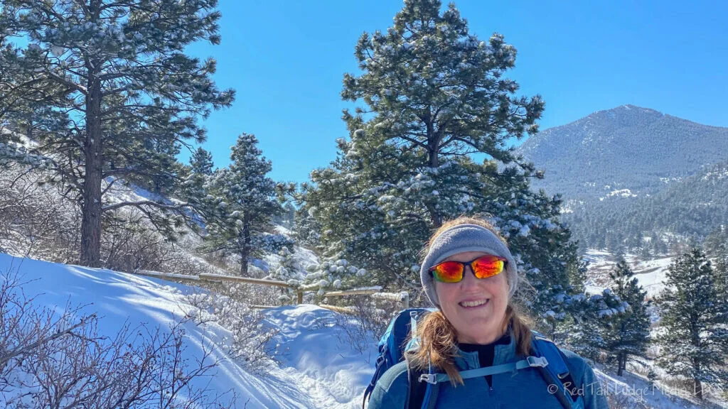
Hike 17 was 7.2 miles with a 707 foot elevation gain in four hours and 30 minutes on February 20, 2020. After trying to hike this trail in November and December, but couldn’t because of muddy trail closures, we finally were able to hike the Flatirons Vista Trail! Third time’s a charm. It was 18 degrees when we started and 36 degrees when we ended, so there wasn’t much mud on the trail because it was frozen. The Flatirons Vista Trailhead is on highway 93. We could hear the highway noise for a little while, but it got fainter the further we went. The trail was mostly covered with a few inches of fresh powder, covering the frozen, icy, and uneven ground. We used our YakTrax (paid link) and trekking poles. The trail was hard on the ankles because you couldn't see what you were stepping on. A few parts of the trail were starting to turn muddy near the end of our hike. The route we took was the Flatirons Vista North Trail to Doudy Draw Trail to the Springbrook Loop Trail. Flatirons Vista North is an exposed trail that follows the power lines towards the mountains, with wide panoramic views. Doudy Draw is in some evergreen trees as it descends down some switchbacks. Springbrook Loop encircles a hill. We took the loop counterclockwise, first heading north. After cresting the plateau on the north side, it enters an evergreen forest. For lunch, we laid down a tarp on a bare spot along the Springbrook Loop to sit and eat. Only one other car was at the trailhead when we started. The other hiker turned around at about half a mile. We didn't see anyone else until just before getting back to the Flatirons Vista Trail, where we saw a handful of other hikers. There were about four other cars at the trailhead when we were done. We were the first tracks from Flatirons Vista to where Doudy Draw split off to the Doudy Draw Trailhead. It looked like a couple of other hikers came from the Doudy Draw Trailhead before we got to the junction. We lost the Springbrook trail a couple of times for a short while because it was covered with snow. We broke trail through a deep snow drift in one section. Only one set of footprints came before ours past the snow drift. It looked like they went off the trail and around the snow drift. When we completed the Springbrook Loop, there were some cross country tracks of people who had come after us, but we did not see the people, just their tracks. As the sun warmed up the fresh snow on the tree branches, the snow would fall, both in big clumps and in flurries of small flakes. We could hear some coyotes, birds and squirrels. We also saw some animal tracks of what looked like coyote, raccoon, and rabbit. The bright sunshine on the fresh snow gave us gorgeous, panoramic views of the mountains and especially of the Flatirons, the rock faces just west of Boulder. The trail definitely lived up to its name!

Hike 18 was 7.3 miles with a 230 foot elevation gain in two hours and 13 minutes on February 27, 2020. We started this hike from our front door. Our route was through Metzger Farm Open Space, before heading north on Big Dry Creek Trail. At 122nd Avenue, we got off Big Dry Creek Trail and headed up the street a few blocks to have lunch at Jersey Mike’s Subs. I guess we were getting a little tired of our normal granola bar and apple lunch that we normally have on our hikes and decided to treat ourselves. It was a sunny day with temperatures in the 40's. Since we were eating out for lunch, we did not use any backpacks and didn’t carry any water on us. Along the way, we saw coyote, geese, hawks, prairie dogs and lots of magpies. Seeing all of the magpies seemed rather appropriate, as we both used to work for a company called Magpie Software Services, which was located just across the street from Jersey Mike’s. RB often walked or rode her bike to work on the same route we walked that day, so it felt like a walk down memory lane.

The temperatures during our February hikes ranged from the teens to the fifties and the weather ranged from blowing snow to bright sunshine and blue skies. Despite the differences (and feeling ill towards the end at Loveland), all four hikes were very enjoyable. We are reminded of a quote from Alfred Wainwright: “There’s no such thing as bad weather, only unsuitable clothing”. It is so true. If you are prepared, you can enjoy hiking in any kind of weather.
Check out our related video: Hikes 15 to 18 in Colorado – February 2020
(RB)