
Hikes 19 to 23 in Colorado - March 2020
We went on five hikes in March for the 52 Hike Challenge. Hike 19 was on Coal Creek Trail from Reliance Park to Baseline Road in Erie. For hike 20 we met a couple of friends from Colorado Springs at Paint Mines Interpretive Park in El Paso County. North Table Mountain in Golden was hike number 21. The next two hikes were both on East Boulder Trail. Hike 22 was on the portion in Teller Farm and hike 23 was the portion from White Rocks to Gunbarrel. We really considered ourselves lucky to work in a hike with friends before our state went into a lockdown.
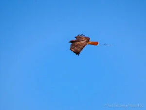
Hike 19 was 11.2 miles with a 270 foot elevation gain in four hours on March 4, 2020. It was a sunny day with temps in the 50's and low 60's. Coal Creek Trail is a somewhat urban hike, so we used our day packs with water and snacks and no trekking poles. The trail is concrete for most of the way with only four miles of crushed gravel. A dozen or so other people were on the trail, biking, running, walking or skateboarding. We started the trail at Reliance Park in Erie. It follows Coal Creek near the neighborhoods of Erie and goes next to the Erie Municipal Airport and Lafayette's solar farm before reaching Baseline Road where we turned around. We saw ducks, geese, crows, prairie dogs, American kestrel, coyote, lots of hawks, and a glimpse of a bald eagle. A hawk was standing guard at its nest. A coyote was trotting down the runway at the airport. There was not much plane traffic. We spotted one plane after it landed. There was an interesting-looking geodesic dome house (two domes connected together) near the airport. Not the most scenic hike we’ve ever been on, but the panoramic views of the mountains from the exposed trail made it quite pleasant.
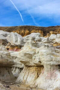
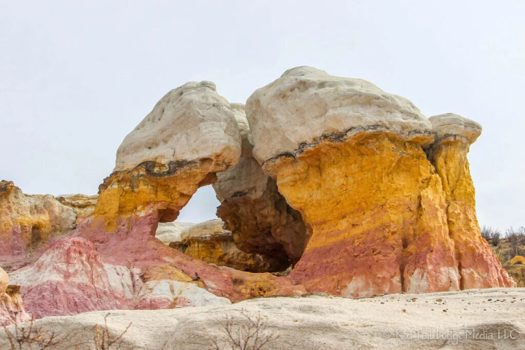
Hike 20 was 4.1 miles with a 405 foot elevation gain in two hours and 15 minutes on March 11, 2020. We met our Colorado Springs friends, Martha and Ernest, at the main trailhead parking lot of Paint Mines Interpretive Park. It was another sunny day with temperatures in the 50's. Again we just used our day packs with water and no poles. There are pretty, colorful rock formations of reds, oranges, and yellows. The trail had a little bit of mud in a couple of spots, but not bad. Humans have been in the area for 9,000 years. The rock formations were used by Native Americans to make paint. Later people used the colorful clay to make pottery. Only one other car was in the parking lot when we arrived around 10 am. By 12:30 pm, the lot was full of cars. Don, a local, was at the trailhead when we finished our hike. He wanted to know what attracted us to the hike. We guess it was hearing about the interesting rock formations from others. We had not heard of the park prior to this year, but now it seems like so many people are talking about it, from neighbors to fellow members in photo clubs. Afterwards, on Don’s recommendation, we ate lunch with Ernest and Martha at Roosters Grille and Pizzeria in Calhan. Left Buddy (LB) had the mushroom sirloin melt with fries. Right Buddy (RB) had the Philly cheesesteak and sweet potato fries. The portions were large and the food was good tasting. On the drive home, we saw some pronghorns. Little did we know that would be the end of our socializing with friends for several months, if not longer.
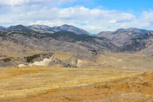
Hike 21 was 6.6 miles with a 1080 foot elevation gain in three hours and 45 minutes on March 18, 2020. North Table Mountain is located on the north side of Golden, which is not far from Denver. We managed to pick another beautiful day to hike, partly sunny, a little breezy, with temps in the 50's. As there was some elevation gain with this hike, we used our trekking poles and backpacks. We parked at the west trailhead at 10:30 am and the lot was almost full. By the time we left, there were several dozen cars parked along the side of highway 93 because the lot was overflowing. We have never been on this trail before, so we don't know what a normal crowd is. However, we're sure the closure of the schools, restaurants, rec centers, movie theaters and the number of people working from home increased the traffic on this Wednesday as people wanted to get out on a nice day before the winter storm struck the next day. Our route for the day was North Table Mountain Loop Trail to Tilting Mesa Trail to Mesa Top Trail to Cottonwood Canyon Trail, then back to North Table Mountain Loop Trail. We also took the spur trail to Lichen Peak which is for hikers only. We originally wanted to add the Rim Rock Trail from Mesa Top, but it was closed. We don't know why it was closed, but perhaps it was too muddy. The trails we were on were mostly dry. The few, isolated mud spots were easily avoided. The beginning of North Table Mountain Loop along with Tilting Mesa and Mesa Top trails were wide, so there was no issue with the mountain bikers and trail runners. However, Cottonwood Canyon and the next section of North Table Mountain Loop (before reaching the mesa again) were very narrow, so we had to step aside to let mountain bikers pass, seemingly about every minute, which detracted from the beautiful hike. However, those sections of the trails were the prettiest scenery as we descended down the canyon and then up another small canyon back up to the mesa. It seemed that most bikers were traveling in the clockwise direction (down the small canyon on North Table Mountain Loop and up Cottonwood Canyon), the opposite direction we were traveling, which meant we would normally see the bikers coming at us. There was one section of the Cottonwood Canyon Trail that was rather tricky for mountain bikers and a small traffic jam was building up as people were attempting to navigate their way through the large rocks on the trail. It was breezy, but not too bad. Considering how exposed the mesa was, we're sure it can be quite blustery on top. People were normally keeping their distance when passing each other on the trail. Keeping six feet apart, as the CDC recommended, was a little more difficult on the narrow trails, but most of the traffic there was bikers and not hikers. LB said he would hold his breath when people passed too close. The wildlife we saw were hawks, prairie dogs, and ducks. Another couple said they saw a herd of deer, but we didn't see it. There were a couple of ponds on top of the mesa. The ducks at one of the ponds definitely had their spring hormones in full gear. One female duck was being chased by a couple of other males. There was a third male that she seemed to prefer and flee toward for protection. We ate our lunch at the Rim Rock trailhead. It looked like there were several areas of rocky cliffs that are used for rock climbing, but we didn't see any climbers. We saw lots of horse hoof prints, but we don't remember seeing any road apples, nor did we see any horses on the trail. North Table Mountain feels more rugged and remote than we had expected, given the view from the trailhead below and its close proximity to Golden. However, the hike would probably be even more enjoyable with less mountain bikers and the challenge of social distancing.
Hike 22 was 6.9 miles with a 273 foot elevation gain in three hours on March 25, 2020. Trying to avoid popular trails but still wanting to explore a trail we’d never been on before that was close to our home, we found the East Boulder Trail on AllTrails. The snow from the previous week’s storm had melted and it was again sunny and breezy, with temps in the 60's. Because the trail was relatively flat and not too far from civilization, we used our daypacks and left our trekking poles at home. We started at the South Teller Farm Trailhead and followed the East Boulder Trail through Teller Farm and continued about a mile into the White Rocks Nature Preserve. The trail is about 6 to 10 feet across in Teller Farm, but in White Rocks the trail is only one to two feet wide. The trail was dry with only a couple of muddy spots that were smaller than the width of the trail. There were not a lot of people on the trail, mostly joggers, people walking their dogs, and others just walking, like families with small children and quite a few senior citizens. There were only a handful of bikers that went by. People were courteous and giving everyone a wide berth. There was lots of evidence of horses using the trail (hoof prints and road apples), but we didn't see any horses on the trail. Wildlife that we witnessed that day were hawks, ducks, geese, prairie dogs, herons and other birds. There was an animal skull alongside the trail that was perhaps a coyote skull. The trail is exposed with wide panoramic views of the mountains in the distance. There are several lakes along the trail. Our lunch was consumed while we sat on a log along the trail at the lake near Boulder Creek, in White Rocks Nature Preserve. We appreciated that Teller Farm was much more peaceful compared to the crowded trails we were on the week before at North Table Mountain.
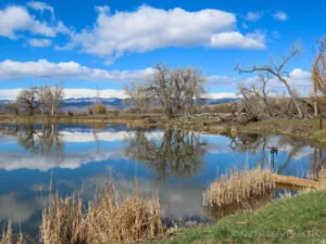
Hike 23 was 9 miles with a 650 foot elevation gain in four hours on March 31, 2020. Wanting to explore the rest of the East Boulder Trail, we started at the North Teller Farm Trailhead and followed the trail all the way to Gunbarrel. We also took the half mile spur to the east to the White Rocks Trailhead. Like a broken record, we picked another sunny and breezy day with temps in the 60’s. The trail was dry the whole day. It started out narrow and then widened with deep ruts when we got closer to Gunbarrel. There was not a lot of people on the trail, mostly joggers and cyclists. Like the week before, people were courteous and giving everyone their space. There were lakes along the trail at the beginning, near Boulder Creek. As we crossed Boulder Creek we could hear frogs croaking. This time we saw several horse back riders on the trail. Hawks, ducks, geese, prairie dogs, herons, western meadowlarks and other birds blessed us with their presence. We heard quite a few meadowlarks, but we struggled seeing them as they blended in with the expanse of grasses. The trail initially headed north, but then turned west before reaching Gunbarrel. The view of the long trail leading off into the distance with the mountains rising up before us caused the song “The Hills are Alive” from the Sound of Music to start playing in our heads for some reason. A bench on top of a ridge just before we reached the houses of Gunbarrel provided us with a great spot to sit down and enjoy our lunch. On the short drive home, we spotted a bald eagle flying overhead. Another peaceful and relaxing hike was just what we needed amid the stress of the pandemic.
It is during times like these that we realize how important it is to get out, breathe fresh air, stretch our legs, and connect with nature. We encourage you to get out and explore the trails and paths out your back door and in your neighborhood. Be safe and take care!
Check out our related video: Hikes 19 to 23 in Colorado - March 2020
(RB)