
Hikes 10 to 14 in Colorado - January 2020

We went on five more hikes in January for the 52 Hike Challenge. Hike 10 was in Eldorado Canyon State Park. For hike 11 we started from our front door and worked our way over to McKay Lake on several trails and neighborhood streets. Pawnee Buttes in Pawnee National Grassland was hike number 12. Friends joined us at South Valley Park in Jefferson County for hike 13. The last hike for the month was in downtown Denver. This month’s hikes were quite a variety of locations and terrain.
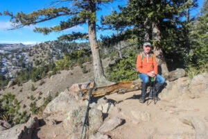
Hike 10 was 6.4 miles with an elevation gain of 1945 feet in five hours and 20 minutes on January 2, 2020. The temps were in the 40s. It was sunny but there was a cold wind. Eldorado Canyon Trail starts out really steep, with steps and tricky boulder sections, sometimes with pretty tall steps or step ups. After a mile, it flattens out a little, rolling up and down, for a little over a mile until we reached the ridge. Then the trail steeply descends for about a mile until it dead-ends into Walker Ranch Loop Trail. Turning left (south) on Walker Ranch Loop, the bridge and the Eldorado Falls are not far, less than a quarter of a mile. Right Buddy (RB) wore her Yaktrax (paid link) the whole time. Left Buddy (LB) only wore them on the west side of the ridge. We could have gotten by without them. There were patches of snow, but not much ice until the bridge on Walker Ranch Loop. Packed snow was around the corner to the bridge. Thick ice was under hard packed snow on the bridge and on the trail on the other side of the creek. The creek was flowing with interesting ice formations. There were not many people on the trail. We stopped in visitor center first to check on the trail conditions. Eldorado Canyon State Park is well known for rock climbing, but we didn't see any rock climbers that day. RB tweaked her right knee on the last steep descent and was in pain for the last half mile, but she recovered quickly the next day. It felt good to get out in the fresh air and get our hearts pumping on the steep terrain.

Hike 11 was 12.6 miles with a 150 foot elevation gain in four hours and 45 minutes on January 7, 2020. It was sunny that day with temps in the 50’s. We stayed close to home for this hike, walking through neighborhoods and open space trails around Broomfield. It was a mix of sidewalks and crushed gravel or dirt trails. A friend driving by stopped to talk with us for a little while. A guy was riding a unicycle at McKay Lake. We were glad to see he was wearing a helmet because the trail was a little rough. A muskrat swam by us in McKay Lake. A lady was looking for her small dog that got off leash near McKay Lake. Only one biker was using the bike park. We spotted three coyotes along Big Dry Creek Trail. There were only a couple of patches of snow, ice, and mud on the trail. We ate lunch on a park bench with a scenic view of McKay Lake and a clear view of the mountains. It was not a strenuous hike like the week before, but rather more relaxing. However, we did manage to get in quite a few miles while we wandered around.
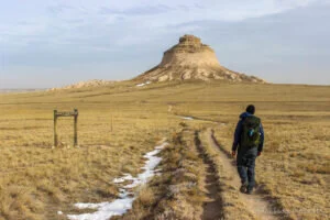
Hike 12 was 5 miles with a 467 foot elevation gain in two hours and 45 minutes on January 16, 2020. It took us about two hours to drive up to Pawnee National Grassland to reach the Pawnee Buttes Trailhead. It was a cold day, partly cloudy with a cold, stiff wind and highs only in the 30’s. We spotted quite a few oil wells along with windmills along the way, both windmills for water troughs and power windmills. We’ve been to Pawnee Buttes before, quite a few years ago, before any of the power generating windmills were installed. The power windmills in the distance make the Pawnee Buttes feel like they are not quite so remote as they did before. Don’t get us wrong, they are still out in the middle of nowhere, with the closest gas station or resemblance of civilization over thirty miles away. On the drive in, we saw a sign at Agland gas in Briggsdale on highway 14 heading east which said no gas for the next 60 miles. We hiked the Pawnee Buttes Trail out past the first butte by following a couple of washes down between two bluffs - the Overlook and Lips Bluff, then traversed a couple of washes. We continued past the first butte and on to the second butte which, unlike the first butte, is on private land instead of being in the Pawnee National Grassland. We followed a small trail around the base of second butte. It was somewhat sketchy and a bit of a scramble up to where the butte goes from straight sides to slanted. The trail is narrow and crumbly at this point. On the way back, we took the Lips Bluff trail which is closed from March 1st to June 30th to protect nesting hawks, eagles, and falcons. There are a couple of sections on Lips Bluff trail that are narrow with drop offs on both sides. It was nothing too scary, but definitely not for those scared of heights. We didn’t see much wildlife that day, but we stepped around some frozen cow patties along the trail. As we were driving out, we spotted a small herd of deer. There was no one else on the trail until we were leaving, when two hikers were just starting out. Another vehicle pulled into the parking lot as we were returning to the trailhead, but it left before we got there. Perhaps it was a government vehicle checking in on things? We didn't use poles, but wish we had them a couple of times. There were a few small patches of snow and ice, but there was plenty of room to go around them. We heard a helicopter for a couple of hours, then it flew right over us near the end of our hike and flew around the buttes. Were they on a flying lesson or training, or just out enjoying the scenery? The trailhead was nice with covered picnic tables and vault toilets, which are needed due to the remote location. We were so glad we had our electric tea kettle in our van so we could make hot chocolate. Sitting in our van sipping our hot chocolate warmed us back up, both physically and mentally. We remembered passing an interesting liquor store in the small town of La Salle earlier that day, so we made a point to stop on our way home to pick up some beer. LaSalle Classic Liquors looks like an old gas station from the fifties. The perfect ending to a day full of backroads and a wonderful hiking adventure.

Hike 13 was 7 miles with a 650 foot elevation gain in four hours and 30 minutes on January 24, 2020. Our friends Dave and Sandy joined us on this hike. They are both Jefferson County Trail Patrol Volunteers and recommended hiking in South Valley Park, which is one of the parks they patrol. We met at the North Trailhead parking lot. From there we hiked Coyote Song Trail down to the south trailhead. Along the way, we went up the Lyons Back Trail to take in the view over the ridge. The bathrooms at the south trailhead were under construction, but there were port-a-potties available which we took advantage of. From there we headed back north, taking the Swallow Trail to get to the Grazing Elk Trail. The Grazing Elk Trail crosses the Valley Road and makes a loop around the plateau near the Lockheed Martin Deer Creek facility. After completing the loop, we continued north on Swallow Trail back to our vehicles. It was a sunny day with temperatures in the 50's. There were some small patches of snow, ice and mud. Only RB took trekking poles. All of us put on our Yaktrax to go back down the steep section of Grazing Elk Trail to get back to the road, due to the slick mud, snow, and icy conditions of the trail. We didn't use the Yaktrax on the way up, but we probably should have. We saw quite a bit of wildlife: deer, coyote, hawk, bluebirds, and some other birds. Our lunch stop was at the start of the loop on the Grazing Elk Trail. The park is full of beautiful red rock formations. The formations reminded us of similar formations in Roxborough State Park, just around 15 miles to the south. Birds' nests can be seen in the rock walls. The bright sunshine that day really lit up the red rocks to give us a spectacular view. Thank you Dave and Sandy for the wonderful hiking company and the beautiful trail recommendation!

Hike 14 was 7.9 miles with a 60 foot elevation gain in three hours and 20 minutes on January 31, 2020. We had arranged to meet with the wonderful VanDOit folks at the Convention Center that morning to check out some new features they have added to their van builds. VanDOit was in town for the Outdoor Retailer Snow Show and graciously spent some time with us. Since we were already downtown, we decided to make a day of it and do more of a city stroll for our hike that week. We took a bus from Broomfield down to Union Station, then walked to the Convention Center from there. After meeting with VanDOit and having a tasty lunch at Boney’s BBQ on Champa Street, we headed the few blocks over to the Cherry Creek Trail which follows the creek in between the two directions of Speer Boulevard, which passes right behind the Convention Center. The Cherry Creek Trail is set up rather nice, with a trail on one side of the creek for pedestrians, and a trail on the other side of the creek for bicycles. When RB used to work downtown, she would often head over to the Cherry Creek Trail for a lunchtime walk. It is a nice break from some of the crowds and you don’t have to stop every block to wait to cross a street. If you take Cherry Creek Trail to the southeast, you will go through Cherry Creek State Park and eventually reach Franktown. We followed the trail to the northwest, where it dead-ends into the South Platte River Trail at Confluence Park, right where REI has its flagship store. And yes, this is a different part of the same South Platte River Trail that we were on for Hike 8. After stopping at REI to try on some boots, we headed south on the Platte River Trail, past Elitch Gardens amusement park, the Children’s Museum, and Mile High Stadium, to 6th Avenue before turning around. On the way back, we continued on the Platte Trail, past Confluence Park, north to Commons Park, then back to Union Station to catch a bus back to Broomfield. When we first moved to Colorado, Union Station was in a pretty bad state, with Amtrak being its only occupant which only ran two trains a day. It was run down and pretty deserted most of the day, not an inviting space at all. A major renovation from 2012 to 2014 brought it back to life and restored it to its former glory with a hotel, restaurants, shops, light rail and bus transit hub while respecting the history and architecture of the original building. The transformation was remarkable and Union Station is now such a joy to visit. It was partly cloudy that day with temps in the 50's, but the breeze was cool. We didn’t see many homeless people along the trails, but we’re not quite sure why because we know the homeless problem is worse than ever. Is there an effort being made to keep them out of sight? The creek and river with ducks and geese give a sense of nature and wildlife to the downtown area. It was interesting to see quite a few people fishing in the South Platte River. The person in their waders fly fishing in the middle of the Platte River just outside REI was a nice contrast with the high-rise buildings behind them. We are not big city people, but Denver is a nice city to stroll around in. Notice that we gravitated away from the traffic, noise and high-rises to the water and parks. However, we do enjoy strolling down the 16th Street Pedestrian Mall every now and then.

We normally associate seeing wildlife and nature in remote parks; however, we saw quite a bit of wildlife in downtown Denver and we’re not talking about strange people on the streets. So we invite you to get out and explore your backyard, neighborhoods, parks, and trails where you live. You might be surprised by what you find! Stay tuned for the next blog post on our February hikes.
Check out our related video: Hikes 10 to 14 in Colorado - January 2020
(RB)