
Theodore Roosevelt National Park: South Unit, North Dakota - October 4th to 6th, 2022

The South Unit of Theodore Roosevelt National Park is larger than the North Unit. It is visited by more people than the North Unit, probably because it sits right along I-94. Most people probably just stop and peer out over the park as they are driving through, but the park is worth staying a few days to explore it deeper.

Tuesday we drove from the North Unit down to the South Unit of Theodore Roosevelt National Park. The two units are only about an hour’s drive apart. There is also a third smaller unit, the Elkhorn Ranch Unit, which is located between the two other units, but it requires a high-clearance, four wheel drive vehicle to reach it.

We first stopped at the Painted Canyon Visitor Center. It is located in a rest area at exit 32 on I-94. That seemed a little strange for a national park, but it is definitely convenient for people passing through on the interstate. They can stop and get a great view out over the South Unit of the park. The Painted Canyon Trailhead is also located here.

After getting some info and eating lunch, we hopped back into our Red Tail Lodge (our camper van) to find a camp site. To reach the Cottonwood Campground, we got off I-94 at exit 27 and drove through the town of Medora to reach the park entrance. There is another visitor center located at the entrance, but we did not stop. The campground is just a few miles from the park entrance.

We had no problems finding an open camp site even though one of the campground loops was closed, but it was early afternoon. The water and flush bathrooms were closed for the season. There was one pit toilet still open. Thank goodness we dumped and filled our tanks at Juniper Campground that morning. We should be good for water the next three days.

It was cloudy in the morning, but the sun was poking through the clouds in the afternoon. We drove the scenic drive, stopping to walk the short trails at some of the points of interest. Normally the scenic drive is a loop, but a section of the drive is closed for a reconstruction project, so it was more of an out-and-back drive for us. Applying sunblock seemed to soothe the itchiness of Ann’s bug bites. Thank goodness, because they were driving her nuts.

Our stops along the way included the Peaceful Valley Ranch, the Wind Canyon Trail, Boicourt Trail, Buck Hill, and Coal Vein Nature Trail. We skipped the Old East Entrance Trail, partly because we had enough for the day and partly because the sign said the trail is usually muddy. The Ridgeline Trail was in the closed section, so we couldn’t do that one.

Peaceful Valley Ranch was originally a ranch from the late 1800’s and has served various different functions over the years until 2014.

The erosion in Wind Canyon is caused by wind instead of water, which makes for some different looking rock formations.

Boicourt Trail is a wheelchair accessible path out to an overlook. We continued on the dirt trail out to a point with expansive views along the way.

Buck Hill is the second highest point in the park, so it has nice 360 degree views. Buck Hill is a short climb up from the parking area. We continued a little bit down the other side for some more views.

The Coal Vein Nature Trail is the site of an old coal vein fire that burned from 1951 to 1977. It was ignited by a lightning strike. Be sure to grab the nature trail pamphlet; otherwise, you may find this trail a little boring. We learned what clinker and clinker chimneys were and started recognizing them elsewhere in the park. Clinker is clay soil that was baked by coal vein fires, turning it into really hard rock. Clinker then become cap rocks on top of hoodoos, as the softer rock and soil around the clinker erodes away more easily.

Along our drive, we encountered some wildlife. The majority was bison, which we had to stop a few times because they were in the road. One large herd just hung out on the road for over ten minutes. We believe they were just trying to assert their authority over their territory. Near the end of our drive, we spotted a couple of feral horses and a handful of white-tailed deer.

On the drive back to the campground, we spotted some puffs of smoke from an active coal seam fire. The area was fenced off to keep people out and safe.

Ann was still being bothered by the intense itching and burning of her no-see-um bites. She read that isopropyl alcohol was a way to treat the bites. She wasn’t sure if it was supposed to reduce the itching or just prevent infections. So she applied rubbing alcohol to all of her bites before going to bed. Surprisingly, it did seem to reduce the itching and she fell asleep quickly. However, four hours later, she woke up itching again. She crawled out of bed and applied hand lotion this time, mainly because she could find it easier in the dark than the alcohol. That calmed things down again and she soon fell back asleep for the rest of the night.

Wednesday morning, we drove back to the Painted Canyon Visitor Center. First we used the strong cell signal there to upload a video, then we hiked the Painted Canyon Trail. There are two trails that start at the Visitor Center. One is a short nature trail at the west end of the rest area, called the Painted Canyon Nature Trail, which descends down into the canyon and comes right back up. The other is a longer trail at the east end of the rest area that descends down into the canyon for a couple of miles, called the Painted Canyon Trail. Make sure you start out on the trail you want; otherwise, you’ll be climbing down and back up out of the canyon twice.

In addition to flush toilets, the rest area has a water bottle fill up station. Since the water was turned off at the campground, we used the fill up station for our water bottles for the hike, instead of using the water from our Red Tail Lodge.

The Painted Canyon Trail starts out following a service road along the rim for about a quarter of a mile before descending down into the canyon. Most of the elevation loss is at this point, which meant that most of the elevation gain was near the end of the hike.

We saw bison tracks, deer or antelope tracks, and elk tracks along with plenty of buffalo chips, but we didn’t see any large wildlife out on the trail. Most of the wildlife we saw were grasshoppers, all kinds of them. It seemed like the parting of the sea as the grasshoppers hopped and flew out of our way as we walking along the trail through the tall prairie grasses.

A large bird flew overhead, probably some type of falcon. Keith caught a glimpse of a snake as it quickly slithered off the trail and into the bushes.

Keith also spotted an unusual-looking spider. We believe it is some type of orb weaver.

In addition to wildlife, we came across interesting rock and erosion formations along with some petrified wood. Some of the hoodoos looked man made instead of natural. The cap rocks sat on top of four sided pillars, eroded perfectly smooth with sharp corners.

Even though it had not rained for several days, there were still a couple of wet spots along the trail along with a couple of small, muddy stream crossings. Thankfully, people had placed pieces of clinker in the streams, making it easy to cross without getting wet or too muddy. There was only one section where the trail crosses a good stretch of bentonitic clay. Ann only slipped once, while she had the GoPro running. She was trying to capture what bentonite was like and ended up capturing more than she bargained for. Nice!

The Painted Canyon Trail ends at the junction with the Upper Paddock Creek Trail. That was as far as we planned to hike. It was rather anticlimactic. So we continued straight onto an unmarked trail up to the top of a small ridge, since it looked like a better place to sit and eat our lunch. From our perch, we could see Buck Hill, which we visited the day before.

By the time we returned to our Red Tail Lodge, we had gone 4.5 miles climbing 495 feet in just under three hours. This was hike number 52, completing our 52 Hike Challenge for 2022!

After filling up our water bottles again at the visitor center, we bought a couple of cold Cokes from the pop machine and sat down in the shade to enjoy them. It was a rather warm day, with temperatures in the 70’s. There was a strong breeze which kept us quite comfortable. This was early October. The prairie and canyon are so exposed. We could only imagine how brutally hot it might be in the summer, with hardly any trees to protect you from the sun. In the winter, we’re sure it can be unbearably cold, as there is no protection from the wind. We’re thankful we picked a great time of year for pleasant weather.

What wasn’t good timing, was visiting the town of Medora. The little town of Medora is right at the entrance to the park. We walked around town, hoping to find a bakery or ice cream shop for an afternoon treat after our hike. However, the tourist season was over and almost all the shops were closed for the season. The town was very cute, so we’ll have to come back some time when things are open. We ended up at the convenience store of the gas station, buying a couple of ice cream novelties. That will have to do, we guess.

Across the street from the gas station is Chimney Park, so we drove over there to eat our treat. The park contains the ruins of the De Mores Packing Plant. The plant operated as a meat packing plant from 1883 to 1907, when it was destroyed by a fire. The tall brick chimney of the slaughterhouse is the most prominent feature that remains.

Afterwards, we went over to the South Unit Visitor Center. The center has a small museum along with a theater where they show the park movie. Behind the visitor center is the Maltese Cross Cabin, a temporary home of Theodore Roosevelt when he was in his mid-20’s. Inside are a few authentic pieces from when he lived there. The cabin is not in its original location. His Maltese Ranch that he owned with a couple of his partners was located south of Medora along the Little Missouri River, outside of what is now Theodore Roosevelt National Park.
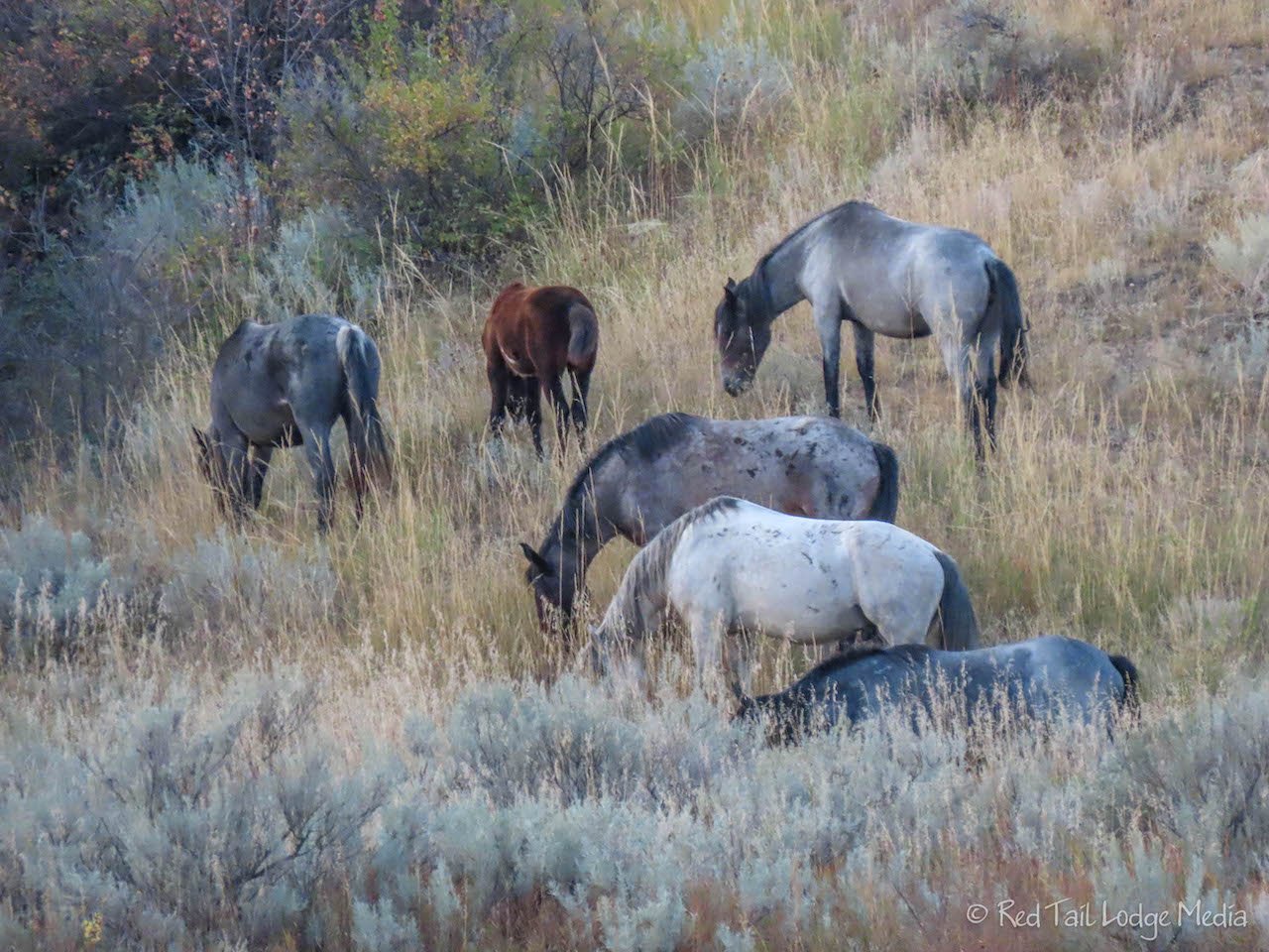
After eating dinner back at our campsite, we went for a walk around the campground. A fellow camper pointed out the herd of feral horses on the far bank of the Little Missouri River. Ann went back to our Red Tail Lodge to grab her camera. We walked out a little ways towards the river to get a closer look.

As we were watching the horses, a couple of women on horseback were approaching along a trail. They looked like they were heading out to camp over night, as they had a third horse with them as a pack animal along with two dogs. When the herd of horses noticed the people and horses approaching, they gathered together and started running towards them. We’re assuming they were trying to protect their territory. The women yelled at the approaching herd, which ran past them.

After the herd was past the horseback riders a little ways, the herd stopped and turned to watch the riders. They seemed to be satisfied that the small group was moving on and the herd did not pursue them again. We’re glad that the two women were not hurt during the encounter. It was an interesting event to observe and we’re not sure if the women were in any real danger.

After another day of applying sunblock in the morning and alcohol before she went to bed, Ann’s bug bites were starting to calm down.

It rained some over night into Thursday morning. By the time we woke up, temperatures were close to freezing. Our plan for the day was to hike the Petrified Forest Loop, which is just over ten miles long. For our pace, we needed to get an early start. However, we were concerned about the rain making the trail slick, but more importantly, we were not motivated to get out there in the cold. Instead, we decided to break it up into two smaller hikes. The two areas of petrified wood are about 1.5 miles from the trailhead. So we could hike to one then return to the trailhead for a warm lunch in our cozy Red Tail Lodge, then hike to the other petrified forest area. That would reduce the ten mile hike to a six mile hike, with a nice break in the middle to warm up. That sounded much better! The information we had said the seven miles along the loop connecting the two areas was on a pretty flat plateau of prairie which didn’t sound all that exciting. However, having a long stretch across the prairie might have increased our chances of seeing wildlife, such as bison, elk, antelope, feral horses, and deer.

The trailhead for the Petrified Forest is actually outside the national park, a 30 minute drive from Medora. From exit 23 on I-94, you drive on gravel roads for about six miles to reach the parking lot at the trailhead. There are no toilets at the trailhead, so be prepared. In about the first tenth of a mile on the trail, you go through a gate to enter back into Theodore Roosevelt National Park. The trail from the parking lot is shared between the North Petrified Forest Trail and the South Petrified Forest Trail for about half a mile, before the trail splits into two. That meant that we traveled this half mile section four times, but it was rather scenic, so we didn’t mind. You could save a mile by going straight over to the South Petrified Forest on the way back from the North (or vice versa), making it a five mile hike instead of a six mile hike, but we wanted to enjoy our lunch in our van.

On the way to and from each of the petrified forest areas, we spotted a few bison in the distance. We believe there were four of them altogether. Surprisingly, the trail was pretty dry. There were only a few spots that were wet or slippery, but very manageable. We were glad we had our trekking poles with us as a few short sections were steep.

There was a lot of petrified wood in both sections. Most of them were tree stumps, although there was one long log laying horizontally on the ground. They were mainly light in color, like they were bleached, with a variety of muted colors of oranges, greens, reds, and blues. Some of the eroded wood pieces on the ground looked like wood chips, but they were rock hard.

Starting out in the morning, we were wearing our puffy coats, hats and gloves to stay warm on our hike. Half way through our two-part hike, we ate our lunch and used our camp toilet before hitting the trail again. Have we mentioned before that we like the convenience of having everything with us in our van? The second half of our hike was warmer, as the sun came out and warmed up the air. Off came the puffy coats, hats and gloves. Had it been that nice in the morning, we probably would have hiked the whole loop.

At the South Petrified Forest, we stopped and chatted with a solo hiker from Florida who was completing the ten mile loop. He said the trail between the two areas, across the prairie, is pretty flat and easy. He saw a large herd of buffalo along the way. He seemed like a nice guy and we wish him safe travels!

On the way back to the campground, we stopped at the convenience store in Medora again for another ice cream treat. It wasn’t as satisfying as an ice cream cone, but we’ll take what we can get!

After the sun had set, on one of Ann’s bathroom trips, another camper told her that the herd of feral horses was down at the end of the campground. Of course, she had to walk down there to take a look. It was a little dark to get any pictures, but it was pleasant to watch them graze in the nearby field for a little while, even with the air temperature dropping. Ann skipped applying alcohol to her no-see-um bites before turning in for the night. At this point they were acting more like regular mosquito bites. Thank goodness!

We’re glad we took the time to stay in both the North Unit and the South Unit. They are very different from one another. We saw more variety of wildlife in the South Unit, from prairie dogs and coyotes to feral horses along with the bison. But our favorite hike was still the Caprock Coulee Trail in the North Unit (Theodore Roosevelt National Park: North Unit, North Dakota - October 1st to 3rd, 2022). Both units are definitely worth days of exploring.
Check out our related video: Theodore Roosevelt National Park: South Unit, North Dakota
(Ann)