
State Forest State Park - June 5th to 7th, 2020

Despite several thunderstorms while we were at State Forest State Park, we really enjoyed our time there. The beauty of the area kept the rain from dampening our spirits.

Coming from Dinosaur National Monument on US 40, we headed north on CO 14 towards Warden after crossing back over Rabbit Ears Pass east of Steamboat. The approach into the mountains from Warden is gorgeous. We camped in the Bockman Campground in State Forest State Park. It was a dirt road to get back into the campground, but it was not a bad road.

As we were getting set up and cooking dinner outside, the mosquitos started swarming us. The bug spray (paid link) and citronella candle (paid link) got us through dinner, then we headed inside the van to get away from the pesky bugs. After finishing the dishes, RB went back outside to do her daily stretches. Miraculously, the bugs were gone!

An ant with wings came crawling across the exercise mat (paid link) towards RB. No matter which way RB moved, the ant turned to keep coming at her. LB was laughing that RB wouldn’t kill the ant. Eventually she managed to shake the ant off the mat and it didn’t come back. RB wasn’t hysterical or panicking, she was just concerned that the ant might bite her since it seemed so intent on coming toward her. Did RB place her mat on top of an entrance to an ant hill? She didn’t see any. She was not quite sure what the issue was. Ants have wings when they are ready to reproduce and can bite, assuming what RB saw was a carpenter ant. There was a lot of rotting dead trees around the park due to pine beetle kill which is a great environment for carpenter ants.

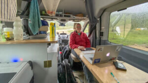
We sat outside for a little while, enjoying the view of the forest and mountains around us, until a thunderstorm came rolling in. It didn’t do much other than sprinkle a little bit, but we were already back inside the van working on our laptops. We could still see the sunset through the large windows of our van.
The next day was a cool, rainy day. We decided to stay in the van and work. We were going to try to hike on Sunday, then drive home afterwards. One of the leaf extensions on the Lagun table top had poked through the cover. LB got out a pair of pliers and bent over the ends to fix the problem.

The weather cleared around 10 am, so we went for an hour walk around the campground and a little ways down Bockman Road. We asked a few kids who were biking back the other way how the trail was up ahead. They said it was fine, but a little “uphilly”.

We made lunch when we got back to the van: tomato soup and grilled cheese. It started raining again, so we worked in the van some more. After an hour, it cleared up yet again and the sun was shining. So we hopped on our bikes and rode down Bockman Road. It was a workout, uphill most of the way until we turned around. The road was a 4WD road, but not too rough for our hybrid bikes. After passing a family walking their dogs not far from the trailhead, we didn’t see anyone else on the trail, probably due to the weather. The road started to get wet and soft, our thighs were starting to feel it, and dark clouds were rolling in, so we turned around. It started sprinkling on us, but we made it back before it started to really rain. Our bike ride lasted about an hour.

We headed back into the van to work. We’ve been watching our battery charge. We haven’t started the van all day, but we’ve used the Instant Pot (paid link), turned on the water heater for lunch dishes, used the electric tea kettle (paid link) a couple of times, the Dometic fridge (paid link) is turned on, running the Fantastic van when we didn’t have the sliding door wide open because of rain, and running our electronics such as charging an electric toothbrush, our laptops, and our cell phones. We were a little concerned because of all the clouds and rain, but the bursts of sun have made a big difference. At 4 pm, our battery charge was back up to 90%.

We made chili for dinner. The rain cleared up and the sun came out for the evening; however, there was a cold wind. We ate outside for dinner, but then headed back into the van for warmth. The campground seems very family friendly. Many people were there with ATV’s. People were playing bocce ball. There were lots of campfires burning. Children were running around and riding bikes. A young girl was trying to learn how to throw a frisbee. Quite a few RV’s had generators, but we didn’t hear any running during the night, despite there not being a camp host. There was information at the camp host site about how to apply to become a camp host. Apparently they are in need of one.

For the second day at State Forest State Park, our original plan was to try to hike up to Jewel Lake. We abandoned that plan for three reasons. First we weren’t sure how close we could park to the trailhead since the trailhead was at the end of a 4WD road and we did not have an internet connection to check the distance and elevation change that we would be adding to the hike by walking down the road. Second, Jewel Lake is above 11,000 feet, so we didn’t know if there was snow on the trail and how passable it might be on foot. Third, LB had a nose bleed the day before and another one during the night. He rarely has nose bleeds and did not want to do a strenuous hike at high altitude.

Instead, we drove up to the end of County Road 41 to check out the view, then stopped at the Moose Overlook on the way back and hiked the short Mountain View Nature Trail. We glanced at the register at the trailhead at the end of the county road and people were noting that there was still deep snow and impassable trails from there on Clear Lake Trail and Kelly Lake Trail. The county road is dirt but in pretty good shape except for a couple of short soft sections that we had no trouble coasting through in our van. The nature trail had an interpretive booklet at the trailhead, but we did not take one. There were several signs along the trail explaining the pine beetle kill, the experiments with how to harvest the dead trees, and how it has affected the health of the forest. At the viewpoint at the end of the nature trail, there was a surprising amount of large clumps of colorful wildflowers.

From there we headed back out to Colorado state highway 14 to the Moose Visitor Center. The visitor center was open, but they required everyone to wear a mask and limited the number of people inside to 10 at a time. The bathrooms inside were also open.

From the visitor center, we hiked the Gould Loop Trail over to Ranger Lakes. We counted this as hike 32 for our 52 Hike Challenge. The trail doesn’t officially start until almost a mile from the visitor center where the trail branches into a loop. We took the branch on the south side of the Michigan River. Much of the area is clear cut from pine beetle kill, but some is through forest. The trail is wide enough for a car in most places and looks like it is also used as a logging road; however, no motorized vehicles are allowed on the trail, just bikes, horses and foot traffic. We saw no one else on the trail all day.

Right after we crossed the Michigan River, there was an old abandoned shack which looked like people had been using to take shelter in. Further along in the woods, logs were propped up into a teepee, with an opening for a door. Perhaps this is used as a shelter to get out of the wind or cold while cross country skiing in winter?

At the eastern end of the trail, it crosses back over the Michigan River near the Ranger Lakes. Just after crossing the bridge, we saw a trail leading off up the hill with a sign for the Ranger Lakes Trail. We took it. It brought us to the southern most tip of the Ranger Lakes. We headed down to the shoreline and found a couple of tree stumps to sit on and eat lunch while we watched people fish along the shore. A single gull flew around the lake, having the place to itself with no other birds around. After lunch and using the vault toilet on the northeast side of the lake, we continued down the trail on the north side of the eastern lake. We noticed all the benches and picnic tables that we passed that would have been much more comfortable while we ate instead of the tree stumps. Oh well, no harm done.

At the east end of the lake, the trail turned rather marshy and was under several inches of water. Luckily a few logs were strategically placed that we could balance on and keep our feet from being submerged in water. We were glad we had our trekking poles with us as it was tricky to keep our balance on the logs, especially the ones that would roll. On the south side of the lake, LB thought he spotted the rump of a moose south of the trail. At first RB thought LB was seeing things as he is near-sighted and she couldn’t see anything where LB was pointing. After she moved over to exactly where LB was standing, she could see that the moose rump was previously blocked by a tree. Just a few more yards down the trail we could see the moose more clearly through a break in the trees. Not only was there an adult moose, she also had a small calf with her! Despite RB’s camera battery about to die (she swears she put the spare battery in her pants pocket!), she was able to take some pictures of them. LB also took a video with his iPhone. The family fishing along the shore at that point along the trail had been watching the moose for a while. The woman told us that she thought that area looked like the perfect spot for a moose when they first arrived there that day. Mothers are always right.

Heading back to where we started the Ranger Lakes Trail, we got back on the Gould Loop Trail. It led us to the Ranger Lakes Campground where we lost the trail for a little while. We knew the Gould Loop Trail ran pretty close to CO 14, so we just headed to the northwest corner of the campground and found the trail again. It looks like the Ranger Lakes Campground used to be heavily wooded, similar to Bockman Campground, but now is pretty open with lots of tree stumps after the pine beetle kill had been cleared out. So now there is a more panoramic view of the mountain peaks to the east. The trail on the way back was a little closer to the highway than we would have preferred, but thankfully the highway did not have much traffic. We made it back to the visitor’s center in about three hours and 45 minutes. RB’s Runkeeper app claimed our route that day was 7.3 miles with an elevation gain of 425 feet. It was a decent length hike that was fairly flat, just what we were looking for that day. We don’t know if it was the altitude (over 9,000 feet) or we are not in that great of shape, but we seemed to quickly get out of breath on the short inclines. It’s a good thing we didn’t attempt the hike up to Jewell Lake that day!

We drove east on CO 14 to Fort Collins which is the Cache La Poudre-North Park Scenic Byway. This took us over Cameron Pass and then Montgomery Pass. There is a trail at Montgomery Pass that leads west to Bockman Campground where we had camped. We saw the Montgomery Pass Road/Trail leading off of Bockman Road during our walk and bike ride the day before. After passing Chambers Lake, we entered Poudre Canyon, following alongside the Cache la Poudre River. It has been years since we’ve taken this drive and, although we remember it was scenic, we just didn’t remember how stunning it truly is, even with the pine beetle kill and fire burn areas.

We stopped at Poudre Falls along the way to get out and take pictures. Unfortunately, the bank of the river is narrow and steep with loose gravel at that point, so safely getting a good look or picture of the falls is challenging. LB was getting a little nervous as RB maneuvered herself along the bank to get a better shot. The chance of surviving a fall into the raging river is probably slim to none. After we started down the road again, there was someone taking pictures up towards the falls from where the shoulder along the road was wider. We did not stop, so we don’t know what the view of the falls is like from there, but it definitely looked a lot safer!

The highway is lined with small National Forest Service campgrounds along the Poudre River. It looked like the majority of them were full as we drove by. Rafters and kayakers were having fun in the rushing water of the river. It took us just under two hours to reach Fort Collins from the Moose Visitor Center and there was not a single minute that didn’t have a gorgeous view. However, 75 miles of twisting road is rather tiring on the driver so LB was happy to let RB drive the rest of the way home when we reached Fort Collins.

It was a lot of fun visiting an area of the state that we had not been in for several years. When the memories start to fade, revisiting an area can seem like a new adventure. We hope you get out and enjoy your favorite places.
Check out our related video: State Forest State Park
(RB)