
Pictured Rocks National Lakeshore, Michigan - July 15th to 18th, 2021

Some places require a little planning and research to truly appreciate them. Pictured Rocks National Lakeshore is one of those places. We made a few mistakes when visiting Pictured Rocks. Luckily we were there long enough to make up for those mistakes. Hopefully you can learn from us.

Thursday we moved from Bay Ridge RV Park in Garden, Michigan, to Pictured Rocks RV Park in Christmas, Michigan, just west of Munising, at the west end of Pictured Rocks National Lakeshore. It is only a one hour drive through a national forest. Several wild turkeys crossed the road in front of us, but Right Buddy (RB) was not quick enough with her camera to get a picture. As we approached Munising, the fog enveloped us. It was too early to check in to the campground and we weren’t going to see many sights in the fog, so we drove an hour over to the Grand Sable Visitor Center at the east end of Pictured Rocks National Lakeshore. By then, the fog had lifted, allowing us to enjoy the sights as we headed back west to Munising. The main road through the park is mostly through the forest, with hardly any views of the lakeshore. To really appreciate the park, you need to take the little spur roads that lead over to Lake Superior.

Our fist stop after the visitor center was Sable Falls. Steps take you down to nice views of the falls. We continued past the falls to where the creek feeds into the lake. There is a sandy beach with views over to the Grand Sable Dunes along the shoreline. After almost returning to the trailhead, we took the other fork in the trail over to the Grand Sable Dunes. At the overlook, we were high above the shoreline with spectacular views out over Lake Superior and along the shoreline.

The second stop was the Log Slide. A short trail led to an overlook at the top of a steep sand dune. On the way to the overlook, we stopped to talk with a father and daughter who looked like they were backpacking. Sure enough, they were. They were spending five nights to go from Munising to Grand Marais on the North Country National Scenic Trail. They only had one more night to go. They parked their car at the Grand Sable Visitor Center in the backpacking lot and a shuttle took them to Munising to start their hike. The full North Country National Scenic Trail stretches 4700 miles across eight states from North Dakota to Vermont. However, the stretch from Munising to Grand Marais is only about 40 miles.

The sand dune led down to a narrow sandy beach along the shore of Lake Superior. It is 500 feet down the dune, 300 vertical feet. There are signs warning people that it will only take a few minutes to get to the bottom, but can take an hour or more to climb back up. Of course, there were lots of people trying. A mother was timing her children. Her young son made it up in 15 minutes. An older daughter took 40 minutes. RB was tempted to try it. She is usually up for a challenge, especially when it is a chance to deny how old she is. Left Buddy (LB) had no interest. He does not care for the feel of sand on his feet. He hurried RB along before she had a chance to talk herself into it.

Our last stop for the day was the Au Sable Light Station. This was the longest walk of the day. The other stops were less than a mile each. The trail to Au Sable Light Station is about a mile and a half each way. The nice wide trail is in the trees, but right along the lakeshore, so you can hear the waves crashing on the beach most of the way. The trail starts out right next to the Hurricane River Campground. The primitive camp sites looked pretty nice, set among the trees.

The lighthouse is on a point, with lovely views of the lake. The sandy beach disappears and the point is pretty rocky. RB continued a short distance down the North Country National Scenic Trail past the light station. She noticed a couple of people picking and eating some berries along the trail. Were those wild blueberries? The couple confirmed that they were. RB tried a couple. The wild berries were smaller than what you buy at the store, but they were packed with flavor. RB took one back to LB so he could try one as well.

On the way back along the trail, there was an informational sign about some shipwreck artifacts along the beach. There was a small set of wooden steps down to the beach, so we went to check out the shipwrecks. The sign said the relics were to the left. We ventured left a little ways, but didn’t see anything as the beach was running out. Thank goodness we decided to head the other direction down the beach, because that is where the boat remains were. There wasn’t much left of the boats, but it was pretty cool to see.

As we were heading back to the stairs, a family recognized us as the Backroad Buddies from the VanDOit Facebook group, so we stopped to chat with them. They are future VanDOit owners, waiting for their van to be built. It was so much fun meeting them!

Closer to the trailhead is another sign indicating that there were shipwrecks on the beach. RB went out on the beach again to look quickly, but couldn’t find any. We were getting tired and didn’t spend much time looking. Our hiking mileage for the day was five miles. We’re guessing that the hiking time was about two and a half hours, with not much elevation gain. We counted this as hike #27 of our 52 Hike Challenge.

By this time, it was getting rather late. We had almost an hour’s drive left to get to our campground and make dinner. Instead, we decided to stop at the Pictured Rocks Trading Company on H-58 for ice cream. Ice cream for dinner? You betcha! They served Chocolate Shoppe Ice Cream from Wisconsin, which we had eaten a few times the week before. And they had RB’s favorite flavor, Zanzibar Chocolate. And their serving sizes were huge. No need to make dinner that night.

Our goal for Friday was to see Pictured Rocks from the water. To really appreciate Pictured Rocks, you really need to view the cliffs from the water. You really can’t see them from the shore.

We booked the Classic Boat Tour with Pictured Rock Cruises starting at 10 am. It was a two and a half hour tour. The information on the web site said that the boarding area opens up one hour before the cruise time and boarding starts 15 minutes before the departure time. Since seating on the boat was first come/first serve, RB wanted to make sure we would get good seats on the upper deck to take good pictures from. So we were there one hour before departure and were the third group in line. Unlike the Wisconsin Dells boat tour where the boarding area had benches to sit on while you wait, the boarding area for Pictured Rock Cruises was a roped off area on gravel. No place to sit down which meant we were standing there for 45 minutes until boarding started. Forty five minutes was plenty of time to stare at the boat and determine the best seat for pictures. It looked like the last row on the upper deck on the right side of the boat was the place to go. In the front, there were obstructions that would get in the way. In the back, you could turn and take unobstructed pictures behind you. Since the stairs came up on the left side of the boat, there was no bench in the last row, meaning no one blocking the view to the left. As we learned from the Wisconsin Dells boat tour, the boat goes slower on the way out as the guide describes all the points of interest and goes faster on the way back, since you are going by the same sights, no explanation needed. This tour pretty much worked the same way. Since the shoreline would be on the right on the way out, that was the side to be on.
We got the ideal seat, but soon discovered we had picked the wrong time of day for the cruise. The cliffs of Pictured Rocks face north, so RB thought the midday sun would be high enough to shine on the cliffs. She should have looked at the map a little closer. The cliffs actually face northwest, so the cliffs were still in shadow the whole time. They were still amazing to see in the late morning and midday, but RB knew she was missing some great shots if the lighting was better. We decided to try again on the sunset cruise that evening. LB checked for available tickets for the 7:30 pm cruise before we even got off the boat from the 10 am cruise. It sounded a little crazy to spend another $80 to take the same cruise later on the same day, but sometimes you just have to splurge a little.

In the afternoon, we drove to Miners Falls and Miners Castle. They are both down Miners Castle Road and are both short trails. Being close to the town of Munising, the trails are heavily used, especially by families with young children. At Miners Castle, there are three overlooks. The lake was pretty calm at the time. The view from the first overlook was gorgeous, as you looked down to the clear, blue water of the lake along the shoreline. The third overlook is on top of Miners Castle. It is also a nice view. However, since we had already seen Miners Castle that morning from our cruise, we knew that seeing Miners Castle from on top of it does not really convey why it is called a castle. The view from the water allows you to see all of the carved out caves that make the rock look like a castle.

We hung out at the park in Munising near the docks. It was a short walk across the street to Miners Pasties and Ice Cream. They also serve Chocolate Shoppe Ice Cream, yay! However, they did not have Zanzibar Chocolate, at least not that day. RB had to settle for Chocolate Raspberry Truffle instead. She gives Miners Pasties a minor deduction for the ice cream flavor selection.

The sunset cruise was fantastic, even better than we had imagined. This time, we did not get the best seat on the boat. People started lining up for the sunset cruise over an hour ahead of time. We got there at 6:30 pm and there were about 25 to 30 people in front of us. Our seats were not bad. We were still on the upper deck, about half way back on the right side. We still had a great view. Seeing the rock formations when they are in shadow does not do them justice. Seeing them during the “golden hour” before sunset was surreal. The colors of the rock formations were spectacular. The water seeping out of the rocks stains them a rainbow of colors, from reds, to blues, to greens, to white, depending on the minerals the water picks up along the way. It truly looks like someone painted the rocks. Our recommendation is to take the sunset cruise. If you can’t get on that one, then at least try for a late afternoon or evening cruise time. Seeing the rock formations in shadow does not really allow you to appreciate their true beauty.

Saturday we went for a hike. Some people we met from Minnesota and Michigan on the Gem Lake Trail in Rocky Mountain National Park last spring told us that their favorite hike in Pictured Rocks was Chapel Falls, so that’s where we went. The route we took was the Chapel Beach Loop. The trailhead is at the end of Chapel Road. When we were at the visitor center on Thursday, the ranger warned us to get there early because it gets a little crazy back in there.

We arrived at the trailhead a little before 8:30 am. Chapel Road is a dirt road. It started out well, then the road got pretty rough in a few spots. Our van made it through OK, but we went slow. There were plenty of parking spots when we go to the trailhead. Since we rushed getting out of the campground that morning, we took our time getting ready to hike. LB had a second cup of coffee. RB off loaded her footage onto hard drives from the day before. After using the vault toilets at the trailhead and brushing our teeth in the van, we hit the trail at 9 am.

The hike was peaceful through a maple tree forest. We could hear the birds singing in the tree tops and woodpeckers drumming on the trunks, but we didn’t see many birds. What surprised us was the small diameters of the trunks of the maple trees. Was that due to the type of maple trees or just due to how dense the forest was?

An overlook for Chapel Lake and the Chapel Falls are on the way to Chapel Beach. The falls were pretty, but the trees blocked part of the view so you couldn’t see all of the cascading falls in one glance. There are several overlooks, on both sides of the falls, to take it all in.

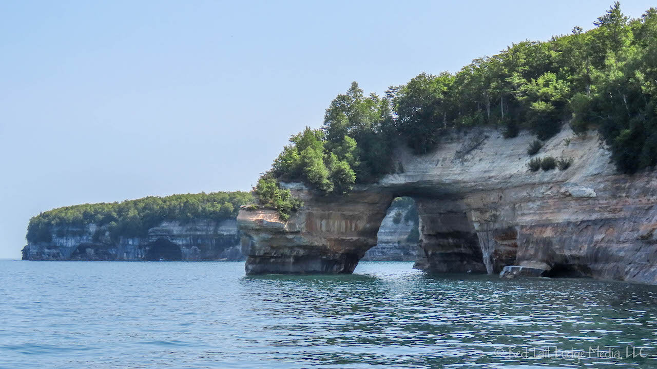
The trail comes out to the beach at Chapel Rock. There is a pine tree growing on top of Chapel Rock, with some of its roots draping over to the main shoreline. At one time, Chapel Rock was connected to the main land. When the rocks eroded away, the tree roots were strong enough to remain.

As we relaxed on the beach, eating our snacks, we watched a kayak tour group paddle around the bay in front of us. Some people were swimming. The water seemed a little cold to us. We were hot from hiking, but the air temperatures were barely in the 70’s. The water temperature probably was a little colder than the air. At the far end of the beach, a few people had climbed up to the top of the cliffs and were jumping into the water.

We were at the beach just long enough for the 10 am Pictured Rock boat cruise to reach Chapel Rock. We could see the cruise boat enter Chapel Cove. They maneuver the boat into a small cove, just barely large enough to fit the boat, with the cliff walls rising up around you. The boat is almost close enough to the cliffs for people to reach out and touch them. It is pretty impressive sailing skills and pretty neat to experience from the upper deck of the boat.

On the way back to the trailhead, we were on the west side of Chapel Lake. However, just like on the east side, there is only one spot along the trail where you can see the lake. There was also a small overlook of Little Chapel Lake to the west of the trail. It seemed like there were more bugs on the trail on the way back. It might have also been the power of suggestion, since we knew we were closer to Mosquito Beach and Mosquito Falls.

The hike was 7.1 miles with an elevation gain of 417 feet in three hours and 41 minutes. We counted it as hike #28 of our 52 Hike Challenge.

After having lunch in the van at the trailhead, we headed back out Chapel Road. The ranger was right, it was a little crazy. Besides the rough road, the parking lot was full and cars were parked along one side of the road for about a mile. There was only room left for one direction of traffic, so it was a little tricky when meeting cars coming the other direction. Luckily, there were not that many cars coming in and there seemed to be a place for one of us to get out of the way every time.

Just a quarter of a mile from the turnoff for Chapel Road along H-58 was a roadside ice cream food truck, so, of course, we had to stop. Unlike our other two ice cream stops in the area, this place served Cedar Crest ice cream. One of their flavors was Dark Midnight Chocolate, so RB was happy. It wasn’t as good as the Chocolate Shoppe’s Zanzibar Chocolate, but it was a close second in RB’s mind. LB decided to have fresh squeezed lemonade instead of ice cream.

For the rest of the day, we relaxed. We hung out again at Munising’s City Park for a little while for the good cell signal, then headed back to the campground to make dinner. The campground is nothing special, but while we were making dinner, a man riding a bicycle with a freezer box on the back was making the rounds through the campground with music playing. Ice cream truck! I mean, ice cream bike! Since LB did not have ice cream earlier, he was waiting patiently with cash in his hand for the man to make it over to our camp site. LB was like a little kid again. He was so excited to find out the man had orange cream-sickles! It was like Christmas! Or Christmas, Michigan. Since RB already had ice cream that day, she bought a drumstick to save in the freezer. The campground’s rank just moved up a notch.

Sunday was a travel day, from Pictured Rocks to Tahquamenon Falls State Park. The state park was only a couple of hours away, so we decided to spend more time in Pictured Rocks. First we drove the road to Sand Point, since it was the only spur road in the park besides Little Beaver Lake Road that we hadn’t driven down yet. The road goes out to a lovely sand beach. It looked like a great place to go swimming or have a picnic, much nicer than the public beach in Munising. On the way back, we stopped at the Minising Falls Visitor Center and Munising Falls. It is a short walk from the visitor center out to the falls. We’re so glad we decided to stop. Munising Falls was our favorite waterfall in the park. Saving the best for last!

Little Beaver Lake Road has vehicle size restrictions, so we had no desire to drive down that road. However, there was one more thing RB wanted to do. She wanted to climb down and back up the Log Slide. LB had no desire to join her, so he filmed RB doing it instead. It was definitely a challenge. It took RB ten minutes to make it down to the beach, and 32 minutes to come back up. The climb down was quite fun. The sand was so steep that each step ended with a slide, doubling the size of each step. At the bottom on the beach, she spent a few minutes taking pictures up and down the beach. Then she started climbing back up. The hardest part was getting back over a couple of hard-packed sand ridges near the bottom. The loose sand made a small channel through the sand ridges. It was flowing like a small stream. RB could not make any headway trying to climb up the loose sand. As she struggled to figure out how to get above the sand ridges, all she could think of was “What did I get myself into? I don’t want to be one of those people that have to be rescued.” Those thoughts motivated her to get past the obstacles. Through a combination of turning around on her bottom, finding some foot and hand holds that held long enough, venturing out along the ridges a little ways, and lifting herself up over the ridges, she managed to get up above the them. After that, it was just a long, uphill climb using both her hands and feet to dig into the steep, deep sand. Each step up was half a step slide back down. RB felt good about accomplishing the challenge, but she would not do it again.

Now RB felt like she earned herself an ice cream. The small town of Grand Marais is just east of Pictured Rocks National Lakeshore. Of course they had an ice cream shop. It is called Sherpa Shack and they served Chocolate Shoppe Ice Cream, yay! They didn’t have the Zanzibar Chocolate flavor that day, so RB had to settle for Chocolate Raspberry Truffle again. That will do. We arrived at Tahquamenon Falls State Park Rivermouth Campground just in time to cook dinner. It was a good day.

So what did we learn from our visit of Pictured Rocks? First, driving the main road through the park does not give you an overview of the park, at all. You need to head down the spur roads to the shore. It’s called a national lakeshore after all. Second, to really appreciate the park, you have to see it from the water, either in the late afternoon or evening, when the sun lights up the colors of the rocky cliffs along the shore. Third, no matter how tempting it might seem, don’t go down the Log Slide. OK, you can use your own judgement on the Log Slide, but if you have to be rescued, don’t blame us!
Check out our related video: Pictured Rocks National Lakeshore, Michigan
(RB)