
Natural Bridges National Monument, Utah - May 3rd to 6th, 2024
Natural Bridges National Monument is not a large park, but we planned to stay four nights there any way. The main attraction are the three natural bridges in the park. A scenic loop road along with several hiking trails connect the three bridges.

Friday was a gorgeous drive from Colorado National Monument in Colorado to Natural Bridges National Monument in Utah. We took highway 128 from Cisco to Moab. Highway intersects I-70 in two places, exit 214 and exit 204. If you are heading west, taking exit 204 is a little longer since you are backtracking a mile or two; however, the road is in better condition.
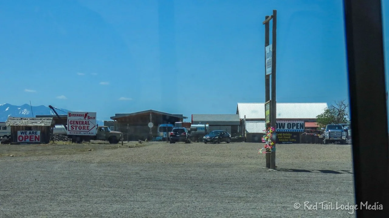
If you get off at exit 214, then you pass by the ghost town of Cisco, but the road is rough. It looks like Cisco is not a ghost town any more. Some people have been settling in. As we drove by, we noticed there is now a General Store that is open. We should have stopped to check it out, but we didn’t decide fast enough and didn’t want to turn around to go back.

We stopped at Rocky Rapid/Ida Gulch Boat ramp for lunch. We sat at the picnic shelter next to the Colorado River, watching the rafters and kayakers floating by. It was a lovely setting for a picnic, complete with vault toilets. The boat ramp was far enough from the highway that the sound of the river drowned out any traffic noise from the road. There are quite a few boat ramps alongside the highway along with several campgrounds. We’ve heard it is pretty hard to get a spot in the campgrounds, as the area is very popular.

Highway 128 is a beautiful scenic drive alongside the Colorado River through a canyon just south of Arches National Park. At Moab, we turned onto highway 191 to head south to Blanding. Although not quite as scenic as highway 128, it is still lovely. Canyonlands National Park and Bears Ears National Monument are just to the west of the highway.

In Blanding, we stopped at the Canyon Country Fuel Center for gas, restrooms, and an A&W Root Beer float. The gas station also has a few bowling lanes. There are other gas stations in town, but none of them have bowling. We didn’t stay to bowl a game, but the A&W Root Beer was good.

Ann also picked up a carton of orange juice. Earlier at breakfast, she dropped her glass bottle of juice, which promptly broke open when it hit the floor of Red Tail, emptying its sticky contents all over. Cleaning up that mess was not how Ann wanted to start her day. But that also meant she didn’t have any juice, which she likes to drink at breakfast.

South of Blanding, we turned onto highway 95, through Bears Ears National Monument to reach Natural Bridges. Yet again, we were on a scenic drive. We arrived at Natural Bridges after 4 pm, so the Visitor Center was closed. We already had a reservation for the campground. The campground is small, only 13 sites. Previously, it was first come/first serve. In fact, that was what we originally thought it was. Luckily, Ann was researching the park a few weeks ago and noticed that it had changed to accept reservations. She was able to snag a site, well, actually two, because there were no sites left that were available for the four nights we wanted to stay. So we’ll have to switch sites on Saturday. We’re so glad we had reservations because, according to the sign at the Visitor Center, the campground is now reservation only besides being full.

There are vault toilets at the campground, but there are flush toilets at the Visitor Center that are accessible even when the center is closed. There is a nice little walking trail, about a quarter of a mile long, from the campground over to the Visitor Center. Ann walked the trail several times that evening to close her exercise ring. It’s a challenge to move enough on travel days, but she has been able to manage so far this season. It was a very pleasant walk, through juniper and pine trees. She tried to identify all the plants along the trail that were identified in the native plant garden outside the Visitor Center. There is also an amphitheater along the trail, but we didn’t see any schedules for planned presentations or programs.

Saturday we switched camp sites, moving just one site over. It took no time at all. The new site was not quite as level, but we only needed a two-by-six under each of the front tires. The view out the back of the site was better. There was a view of the cliffs on the other side of the canyon.

Our activity for the day was riding our bikes around the nine mile loop road. Bikes are not allowed on the trails. The road is one way around the loop. It is narrow, with not much shoulder, but the speed limit is only 25 mph and traffic was not heavy. Still, we needed to pay attention to when cars approached us from behind. Sometimes we would stop as vehicles went around us.
The road is not level, rolling up and down the whole way. Some short sections were rather steep so we were glad we had e-bikes and could turn on pedal assist. We still wanted a physical workout, so we generally only turned on levels 1 or 2 out of 4 going up the steep inclines. Otherwise, we had the assist turned off. Our battery levels were still 5 out of 5 when we were done.

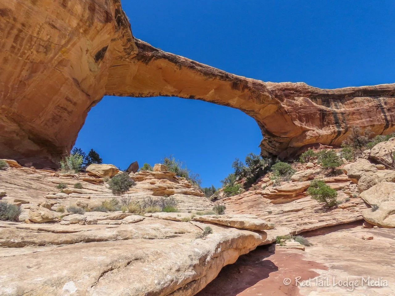
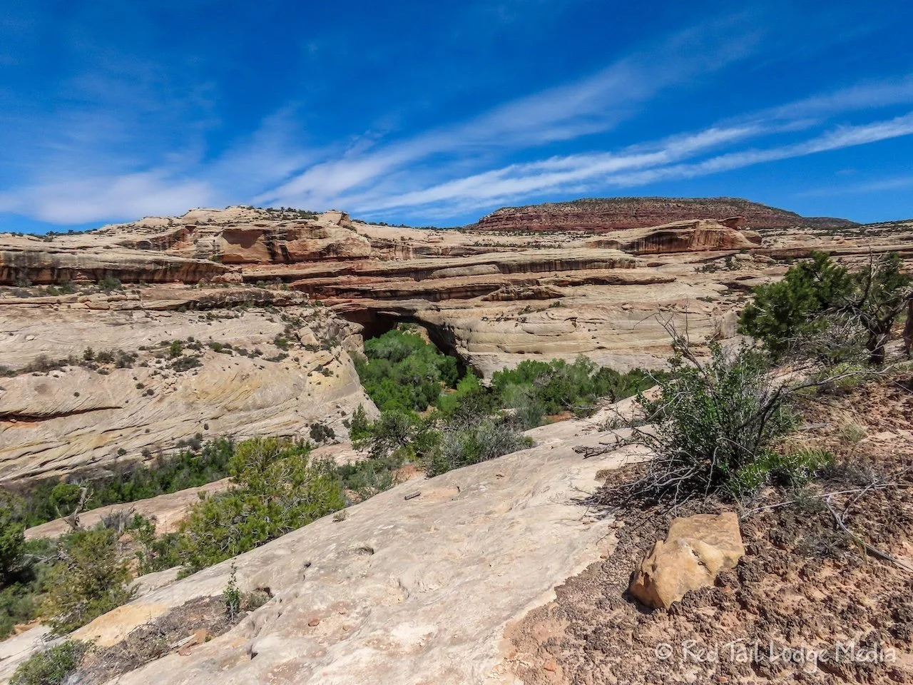
We stopped at the overlooks along the road. There are overlooks for each of the three natural bridges, Sipapu Bridge, Kachina Bridge, and Owachomo Bridge, along with a short trail to an overlook of the Horse Collar Ruins. There were good views of two of the bridges from the overlooks, but the Kachina Bridge was hard to make out from the overlook.

Natural bridges differ from arches in the way they are formed. Bridges are formed when meandering streams circle back on themselves. They create a pinch point where the stream eventually erodes through the bank from both sides and punches through the sandstone. The stream then flows through the short cut, abandoning its original course.

It took us about three hours to complete our bike ride, including two stops at the Visitor Center, all the overlooks, and lunch at the Kachina Bridge overlook. We were only cycling for about half of that time, covering almost 11 miles. Since the speed limit was only 25 mph and the road was one way, we would see many of the same people at each of the overlooks. It was a very enjoyable day.

At our last stop at the Visitor Center, we watched the park movie. It was only ten minutes long, but, as most National Park movies do, it presented wonderful information about the park.

After dinner, we walked over to the Visitor Center to check our emails. There is no cell service in the park, but there is free Wifi at the Visitor Center, if you stand right up next to it. We were not the only ones standing there to use the internet.

There was a high wind advisory for Sunday, so we cancelled our planned hike and just hung out in Red Tail. We made a few walks to the Visitor Center to get some exercise, check our emails, pay an invoice, and try to download some music for the Balloon Fiesta video (Albuquerque Balloon Fiesta, New Mexico - October 7th to 14th, 2023). Picking out the music and downloading it was a painful process since the wifi was pretty slow and Ann got cold sitting outside in the wind.
The weather surprised us and rained off and on most of the evening. We don’t remember there being any rain in the forecast. Hopefully it didn’t rain enough to make the trails wet so we could still hike on Monday. Hiking on wet slick rock is not advisable.
Monday morning was sunny, but cool. There were a couple of puddles, but the ground was mostly dry. A great day for hiking.

The planned hike for the day was the Kachina to Owachomo loop. There are two main hiking loops. The other one is Sipapu to Kachina loop. The one we took is the slightly longer one. If you are really ambitious, you can combine the two loops into one large loop.

We parked at the Kachina Bridge parking lot, the only one with a toilet, not that it mattered because we had one with us in Red Tail. You could start and end at the Owachomo Bridge parking lot instead.
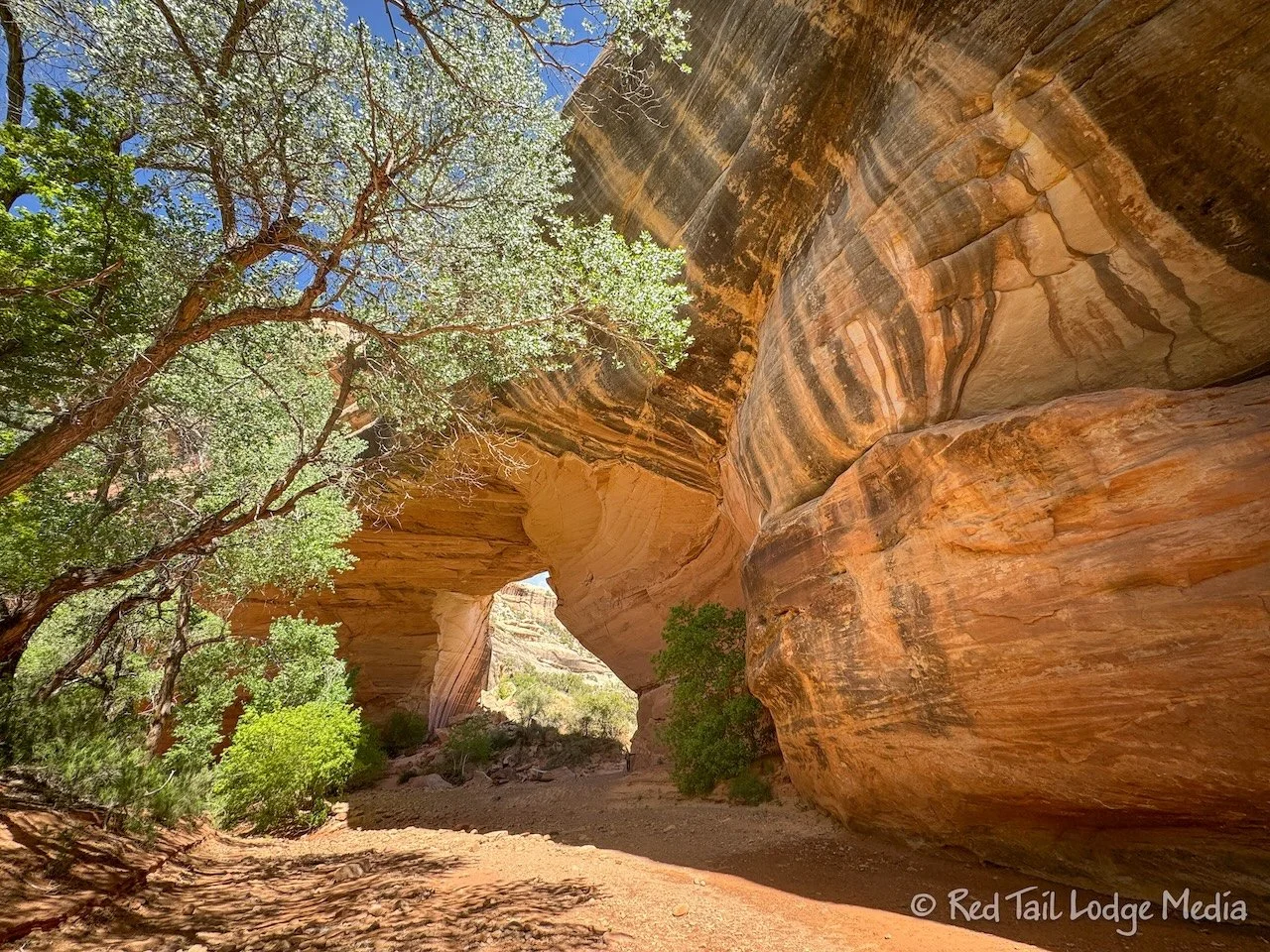
The trail descends into the canyon, then splits. One direction goes towards Sipapu, the other towards Owachomo. Even though we were heading for Owachomo, we started out towards Sipapu, so we could walk under the Kachina Bridge. At the bridge, we turned around and headed back towards Owachomo.

The trail follows the bottom of the canyon over to Owachomo. It is an unimproved trail and hard to follow in sections, especially since there are several trails at some points, so you are not certain which one to take. But, as long as you stay in the canyon, you won’t get lost. The trails are rather overgrown, so we were glad we were wearing long pants and long sleeves.

The stream at the bottom of the canyon was not flowing. In most places it was dry, but there were areas with trapped water, with some of those areas being rather large. At one point, we had to scramble up a sandy bank to avoid wading through water. We must have missed a turn up onto the bank somewhere. Some of the bodies of water had tadpoles swimming in them, hundreds if not thousands of them.
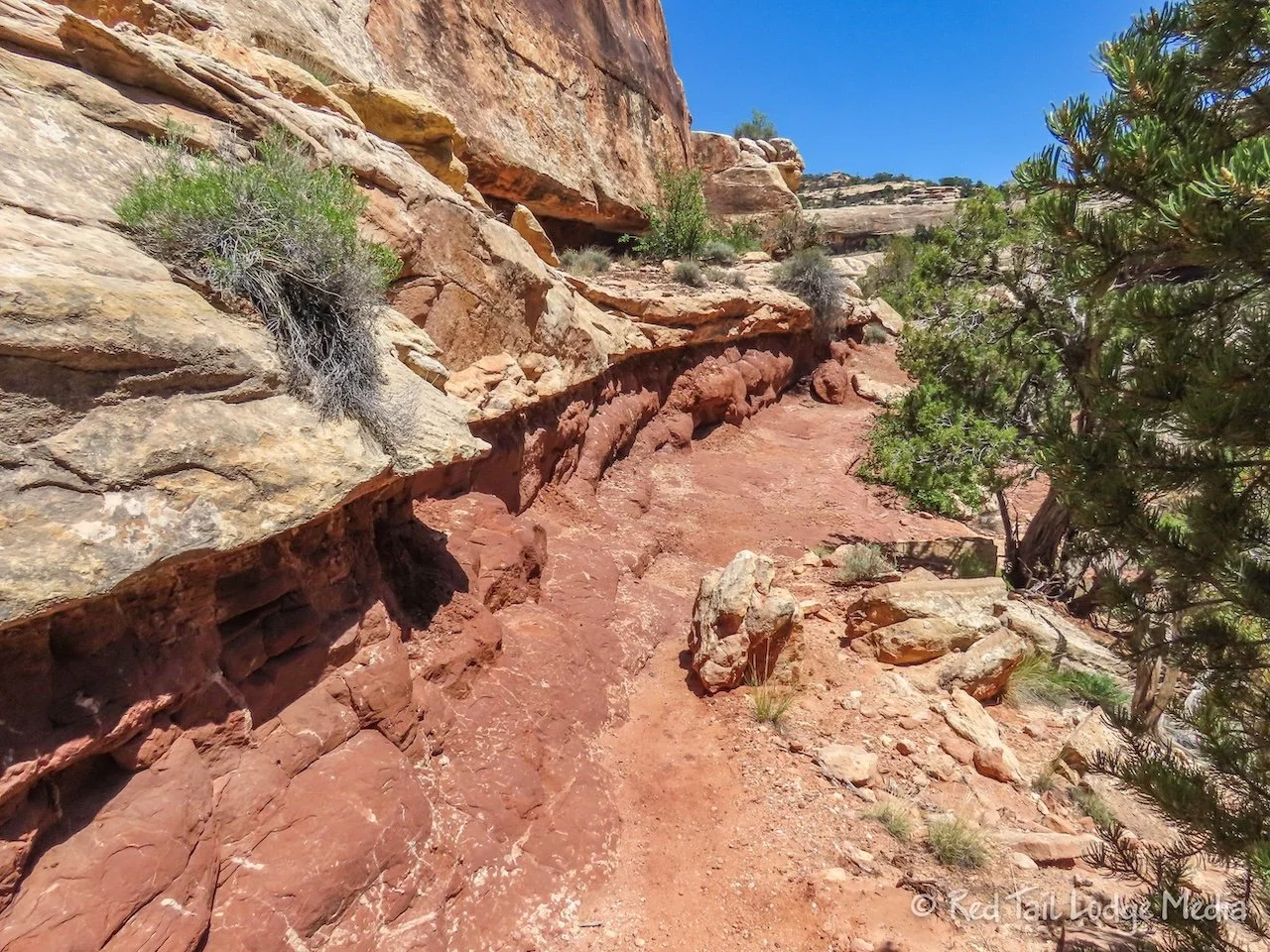
The terrain within the canyon was constantly changing. Sometimes we would be walking on sand, through thick willow and sage brush, or under cottonwood trees. At other times we were walking on slick rock, with bare canyon walls around us. Or we would be negotiating the rocky, dry stream bed. There were supposed to be petroglyphs and hanging gardens in the park, but we didn’t see any. Perhaps we just didn’t notice the petroglyphs, although we thought we were keeping an eye out for them. And perhaps we were too late in the spring to see hanging gardens. Or we were just on the wrong trail to see them.

Our progress was much slower through the canyon than we expected. We were hoping to make it to the Owachomo Bridge before having our snack, but it was taking too long and we were hungry. So we found a nice boulder to sit on and ate most of our food.

We were so excited to see the Owachomo Bridge come into view when we rounded the last bend. We sat on a rock, enjoying the view of the bridge and the rest of our food.

From the bridge, it was a short climb up to the overlook and parking lot. To return to the Kachina parking lot, there is a trail that crosses the mesa, called the Mesa Trail of all things.

From the map, the Mesa Trail looks pretty straight, but it wasn’t. It starts out going through the PJ forest (pinyon pine and Utah juniper trees), with cryptobiotic soil stretching out in every direction. But then the trail crosses the road and winds across some slick rock. There was even a short ladder to climb up. We were not expecting that.

The Mesa Trail then crosses back over the road to return to the PJ forest. Then the trail splits, with one going towards the Kachina parking lot and the other continuing on to the Sipapu trailhead parking lot. The split was well marked, so there was no danger ending up at the wrong parking lot.

By the time we returned to Red Tail, we had covered almost 7 miles with an elevation gain of 938 feet which took us almost five hours to complete. It was hike number 12 of our 52 Hike Challenge for 2024.

We’re glad we stayed four nights, even though you could see most of the park in one day. Four nights gave us time to relax and avoid going out on a bad weather day. Had Sunday been the only day we were at the park, we would have had a miserable time. Being retired, we have the luxury of time, so we took full advantage of it.
Check out our related video: Natural Bridges National Monument, Utah
(Ann)