
Golden Gate Canyon State Park, Colorado - May 21, 2020
After getting a taste of hiking in the mountains again the week before, it was hard to go back to walking the neighborhoods, so we pushed the ten mile radius rule again and went up into Golden Gate Canyon State Park for hike number 30 of our 52 Hike Challenge. We actually felt safer because not many people were there.

It was a mostly sunny day, but cool - in the low 50's. We drove into the park on Gap Road, which is a dirt road but in good condition. We didn’t stop at Panorama Point on our drive in because we would reach it during our hike. You can get to Panoramic Point by car, but what is the fun in that? Actually, we’ve been to Panorama Point by car before. In fact we have a picture of Right Buddy (RB) with our son as a toddler at the Point from the first time we came to Colorado. After passing Panorama Point, we turned south on Mountain Base Road to Bootleg Bottom Trailhead. Mountain Base Road is a paved road, but we believe we saw a sign that said no RV's or trailers are allowed on the road, probably due to how narrow and twisty it is.

We started our hike at Bootleg Bottom Trailhead on Mountain Base Road, headed east on Coyote Trail, then north on Mule Deer Trail to Panorama Point, continued on Mule Deer which loops back south to Bootleg Bottom trailhead. Raccoon Trail joins Mule Deer before and after Panorama Point, which can be a little confusing. The route we took according to AllTrails is 6.7 miles with an elevation gain of 1236 feet. It took us about five hours to complete the loop, including time for lunch. We originally were thinking of hiking Mountain Lion Trail, which is more to the east, until we found out it is in the area of the state park where hunting is allowed and the hunting season was not over until a few days after our hike.

We're glad we hiked this loop in the counter-clockwise direction instead of the clockwise direction, because the section of the Coyote Trail that we were on was pretty steep and some of it was on steep slip rock. We would much rather go up that than down. Going down is always harder for us with our old knees and legs, especially when we are going slow to avoid any mishaps. Not far from the trailhead on Coyote Trail is a cabin that was used by bootleggers during Prohibition which is where the trailhead gets its name. There is also a rusty old abandoned steamroller. We’re not sure how it got there, perhaps it tumbled down the hill?

Mule Deer Trail is a very comfortable trail with not many rocks and quite a bit of soft dirt. We ate lunch on some boulders along Mule Deer Trail before reaching Panorama Point. Between Coyote Trail and Panorama Point, the Mule Deer Trail gradually climbs through a beautiful evergreen forest with pockets of aspen groves and small meadows. The leaves were just starting to come out on the aspen trees. There was a couple of small patches of snow on Mule Deer Trail before crossing Gap Road.

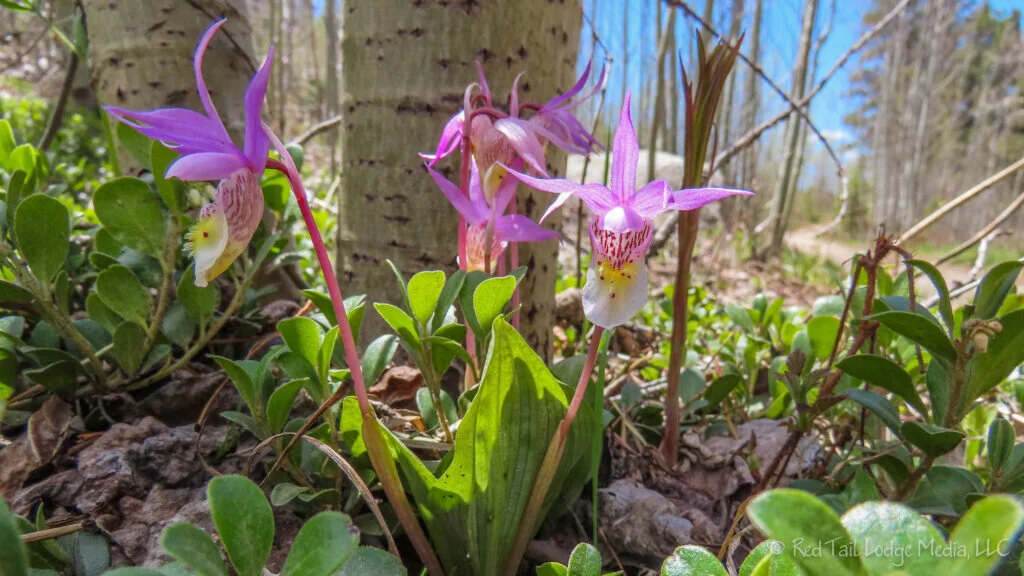
Panorama Point lives ups to its name with nice views at the Point and along the trail just before reaching the Point. We only saw a couple of wild flowers, but we're guessing in a week or two there should be lots of them as there were plenty of sunny spots with plants that looked like they might flower. The only wildlife we came across were some birds and squirrels.

We crossed paths with only about a couple dozen people the whole time we were on the trail, despite the parking lot at Panorama Point. They were a combination of mountain bikers and hikers. Only hikers are allowed on Coyote Trail, but bikers and horses are also allowed on Mule Deer Trail.

After our hike, we drove out the opposite direction from the trailhead, taking Mountain Base Road south to Golden Gate Canyon Road, past the Visitor Center where we headed northeast on Crawford Gulch Road. The road changes names a few times (Ralston Creek Road and Drew Hill Road) before joining back up to Golden Gate Canyon Road. It turned to a dirt road part of the time, not in as good of condition as Gap Road, but nothing our van could not handle. It was nice to see families fishing at Kriley Pond as we drove past.

Golden Gate Canyon State Park has campgrounds and yurts to rent, but they were still closed the day we were there. We’ve camped in the group campground before, years ago, with the Boy Scouts. We fondly remember the kids climbing on large boulders near the campground and trails leading off into the woods. A former coworker of ours loves to rent a yurt there often as an escape for his family. It is a great place to get away, and is not that far from Golden and Denver.

We felt a little guilty for stretching the ten mile radius rule again, but we didn’t feel like we were increasing anyone’s risk. We wore our masks and kept our distance from everyone. Our advice is to get outside when you can, but be smart and stay safe!
Check out our related video: Golden Gate Canyon State Park in Colorado
(RB)