
Day One on the Appalachian Trail - July 29, 2019
From Pensacola Beach, we drove north to Atlanta to watch our daughter perform in the DCI Southeastern Championship in the Mercedes-Benz Stadium. Then we continued on to the Nantahala National Forest to prepare for our three day backpacking trip on the Appalachian Trail. We were both excited and a little nervous.
We don’t know what we were thinking, but we managed to time our drive from Pensacola Beach to Red Top Mountain State Park so that we were driving through Atlanta right at rush hour on a Friday evening. Ugh! The drive back into Atlanta to the Mercedes-Benz Stadium for the DCI competition the following day was not as bad, for Atlanta that is. Red Top Mountain State Park looks like a lovely park, but we didn’t spend much time there. We mainly picked the campground for its location and laundry facilities. The campground was about 45 minutes from the stadium, depending on traffic. Before heading to the stadium, we took our bikes and hitch off the van and locked them up at our campsite because we weren’t sure what the parking options would be near the stadium and parking garages are off-limits due to our van height. We ended up at the Blue Lot, which is a surface lot that could have easily accommodated the extra length of our bikes. There were also a couple of smaller surface lots closer to the stadium, Lot M and the Mercedes-Benz Lot, but we don’t know how their prices compare to the Blue Lot. The concessions at the stadium were very reasonably priced and we liked that the soft drinks were self-serve with free refills (Coke products, of course, since Atlanta is Coca-Cola’s headquarters). However, the stadium was freezing cold, at least where we were sitting. By the end of the competition, both of us were literally shivering. Somehow we didn’t think to bring heavy jackets and sweat pants into the stadium with us in late July.

On Sunday, we headed for the Nantahala Outdoor Center (the NOC) in North Carolina. Along the way, we stopped in Andrews NC for an ATM and a park to have lunch. We found Harold H. Hall Memorial Park near the center of town. While we were eating, Right Buddy (RB) was spying some pretty flowers near the railroad tracks. Of course she had to walk over there with her camera to check them out. As she got closer, she discovered a bonus. Lots of butterflies were enjoying their lunch among the flowers as well.
During our drive to the NOC, RB made several phone calls and sent a few emails to shuttle services to try to arrange a ride from the NOC to the Winding Stair Gap trailhead for the following morning. In hindsight, we probably should have arranged this a week or two sooner. We were using the shuttle service information found in the Northbound Interactive PDF of the A. T. Guide that we had purchased previously. We eventually made arrangements with Jim Granato. For $40 per person, he would meet us at 8 am in front of the mini-mart at the NOC and drive us to the Winding Stair Gap trailhead, about an hour’s drive away. Perfect!
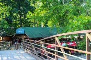
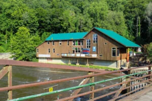
The NOC is located right where the Appalachian Trail crosses Highway 19 near Bryson City, NC. It is in the beautiful Nantahala Gorge along the Nantahala River. The center caters to white water rafting along with kayaking and zip lining. It has a couple of restaurants and stores along with some live music in an outdoor seating area. It also has lodging in cabins, bunkhouses and a motel. So it is quite the oasis for thru-hikers of the Appalachian Trail. Our plan was to hike the Appalachian Trail from Winding Stair Gap to the NOC over three days, so we needed a place to park our van during that time. From our research, we knew that the NOC allowed people to park vehicles there while they were on the trail. We went into the Outfitter’s Store to get more details. Even though there was no charge, there was a form to fill out which let the NOC know what days we were going to be on the trail. They provided us a map which showed us where to park at their basecamp area along with a permit to display in our windshield. We asked, but, unfortunately, they do not allow people to camp in their vehicles there. So, after enjoying a nice dinner at the River’s End Restaurant and soft serve ice cream at the Big Wesser, we drove over to the Tsali Forest Service Campground, less than ten miles away, to camp for the night.

Waking up bright and early on Monday, we ate a quick breakfast, packed up and drove back over to the NOC. We had no problem finding the basecamp parking area and had plenty of time to get over to the mini mart to meet our shuttle driver Jim. Jim kept us entertained the whole way to the Winding Stair Gap trailhead. He doesn’t hike himself, but he is quite knowledgeable about the trail and the surrounding area. He’s retired and was full of stories to tell. Jim shuttles hikers for entertainment and company, that is when he is not searching for rubies and garnets in the local streams.

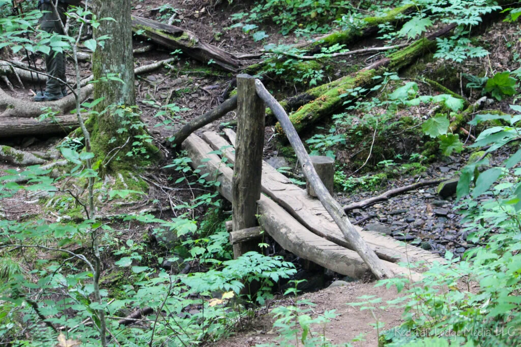
We were on the trail by 9:15 am. LB was carrying over 33 pounds. RB was carrying 35 pounds which included five pounds of camera gear. The section of the Appalachian Trail from Winding Stair Gap all the way to the NOC is a little over 27 miles, from northbound mile marker 109.4 to mile marker 136.9. Since we were planning to be on the trail for three days, we were hoping to cover about nine miles each day. Therefore, we wanted to make it to the Wine Spring campsites at mile marker 117.6 by the end of the first day. We were a little anxious to get some miles behind us since we were unfamiliar with the terrain and not sure what pace our bodies could handle. Our shuttle driver Jim had told us to look for the waterfall within the first mile. We saw the waterfall, but RB didn’t even stop to take a picture of it as we nervously plowed on ahead up the 1300 foot elevation gain to Siler Bald.

Before we reached the Siler Bald Shelter, we saw a good place to wander off the trail and relieve ourselves. As we were taking turns watching each other’s packs, another hiker passed by. He was the first person we had seen on the trail all morning. We made it to the Siler Bald Shelter in time for lunch. The shelter is half a mile down a side trail at mile marker 113.6. So we covered a little over four miles and 1000 foot elevation gain in a little over two hours. That wasn’t bad. We were starting to feel a little more at ease. At the shelter we met back up with the hiker that had passed us earlier. His name is Steve, aka Duct Tape. He was given that trail name due to the numerous rolls of duct tape he has used to try to hold his favorite hiking boots together. He started the trail at the southern terminus of the trail.

There was also another hiker at the shelter, Bruce. He also started at the beginning and has been keeping Duct Tape company for a few days. Enjoying the conversations with the other hikers, we must have lingered at the shelter for about an hour. As we were heading back to the trail from the shelter, we ran into two more hikers, Kristine and Karen. They were hiking the same section that we were, from Winding Stair Gap to the NOC. We headed back to the trail the same way we approached the shelter, along the southern end of the shelter loop trail. The information that Steve and Bruce had said that the northern part of the loop trail was a little tricky. However, what we didn’t realize until later, was that we missed the Siler Bald summit along with a great view.

From Siler Bald, the trail heads downhill for about 800 feet elevation loss over a couple of miles to Waya Gap. Left Buddy (LB) had not been feeling good most of the day, needing frequent bathroom stops. The National Geographic topographical map guide that we had showed a restroom at Wayah Gap, but we couldn’t find it. LB was not happy. There was a couple of day hikers that passed us, but they didn’t know where the toilets were either. If we had taken more time studying the map and guides that we had, we might have realized that the restroom was probably down a short side trail to the Wayah Crest Picnic Area.

From Wayah Gap, the trail started rising again. It was about 1000 foot elevation gain over the next couple of miles to reach the Wine Spring campsites. We reached camp around 5 pm, which was plenty of time to set up camp and make dinner before dark. It was at this point that we discovered RB did not have her backpacking spoon. At the last minute, she had switched out her Lifestraw for a micro Sawyer Squeeze (paid link) for filtering water. Her spoon was in the bag with the Lifestraw. RB decided against the Lifestraw since it cannot be used to filter water for cooking. Then we couldn’t get LB’s backpacking stove to work. That meant that we took turns cooking and eating our dinner. After dinner, we hung our bear bags from a tree. As it got dark, there wasn’t much to do, we were tired, and sitting on a log was not that comfortable, so we turned in early. As we changed into our bed clothes, we wiped our bodies down with a wet bandana and rinsed out our underwear and socks. Feeling refreshed, we tucked ourselves in for the night.

One day of hiking was complete. We were expecting to see more people on the trail. However, it was a weekday, so that kept the number of day hikers down. As far as thru-hikers go, the northbounders should all be past this point by now and it is too early for the southbounders to get this far. We knew that the Appalachian Trail is heavily wooded and under a tree canopy most of the time, but we were expecting there to be views every now and then. Other than one small meadow, we had no views all day. Of course, we missed the Siler Bald summit. There were other things to see though.

A couple of times we passed through groves of mountain laurel trees, but there were not many blossoms left as it was a little late in the season for them. There were quite a few wildflowers along the trail every now and then where the sunlight peeked through the trees. Due to the moist environment, there was an abundance of a variety of mushrooms and other fungus, with some of them quite large and vibrant in color. We didn’t see any large wildlife, but did see quite a few little critters, like moths, butterflies, millipedes, snails and slugs.

A pleasant surprise for RB during the day was how great the water was. RB had never filtered water while hiking before. She was a little apprehensive about what it would be like. All of the water sources along the trail are from springs. The water was clear, cold and refreshing. RB would even say it was some of the best tasting water she’s ever had.

One thing that surprised us was how dark and silent the night was. Probably due to the dense canopy of trees, not only could we not see any stars, but it was so dark that we could not even see our hands in front of our faces. RB loves hearing the sounds of nature while camping in a tent, but it was totally silent. No crickets chirping, no frogs croaking, no cicadas clicking, nothing. It was kind of spooky. It was total silence until the birds started chirping in the morning.
Check out our related YouTube video: Three Days on the Appalachian Trail 2019.
(RB)