
Acadia National Park: Blackwoods, Maine - October 3rd to 6th, 2021

Visiting Acadia National Park in the fall was the inspiration behind our Season Three travels. Left Buddy remembers visiting Acadia as a child with his family, but Right Buddy had never been before. To thoroughly enjoy our time at Acadia, we reserved four nights in the Blackwoods Campground and three nights in the Seawall Campground with a night in between staying with friends who have a house nearby. This post only covers our time at Blackwoods Campground. Following posts will cover the rest of our time at Acadia.

It was about a three hour drive from Boothbay to Acadia National Park on Sunday. We stayed on US 1 most of the way there, passing through some cute little towns along the way. Camden looked especially nice. It was raining so we did not stop to check it out. We’ll have to add that to our list of places to come back to. A little ways past Camden, we crossed the Penobscot Narrows Bridge, an interesting structure. We could see people at the top of one of the towers of the bridge, but we did not stop to check it out. There is a small entrance fee to go up to the observatory in the tower, but the fee includes visiting the nearby Fort Knox Historic Site, which is a Maine state park.

By the time we reached Acadia, the rain had stopped. After eating our lunch outside Hulls Cove Visitor Center, we started our drive on Park Loop Road. Just before reaching Cadillac Summit Road, the Park Loop Road splits. The split to the right is a two way road, while the fork to the left, heading towards the shoreline, is one way. We took a sharp left towards the shoreline. The trees were just starting to turn their fall colors. There were nice views out over the water, but we did not stop at any of the overlooks. The one way road is two lanes wide, but parking is allowed in the right lane in many sections.

When we passed through the park entrance station, the ranger asked us several times if our van was under 10 feet tall. There are several bridges the park road passes under, with the lowest clearance being only 10 feet 4 inches. Yes, we were sure our van was just under 10 feet. Even so, we went through the lowest underpass at a slow speed, hugging the center of the road where the bridge looked the highest.

We parked in the right lane, just before reaching the Sand Beach parking area. It looked like parking in the lot might be an issue, given all the cars parked along the road and all of the people walking beside the road. The Sand Beach is at the end of a small cove, with dark, rocky cliffs lining the sides of the cove. The ocean water was crashing over the rocks. A pretty sight to see. It was too cold and cloudy for anyone to be sunbathing on the beach. According to the informational sign, the water is “wicked cold”, so no one was swimming.

From the beach, we hiked down the Ocean Path Trail to Otters Point. The path is a little over two miles from Sand Beach to Otters Point. The views of the rocky shoreline are spectacular. Little side paths allow you to walk out onto the rocky boulders for a closer look.

The Ocean Path goes by Thunder Hole. Thunder Hole is a narrow channel in the rocks where the waves roll in and cause a low sound when the waves reach the end of the slot and force the air out, hence the feature’s name.

Along the way, we also passed a couple of wedding parties. We’re not sure if they were just taking wedding photos or actually conducting a ceremony right along the shore. What a stunning backdrop for them!

Some people who passed us going the other way said they saw a couple of sea otters and a sea lion further up the trail. We kept our eyes peeled, but we did not see any wildlife in the water or on the rocks except for birds. At one point, we thought we saw something in the water, but we’re not sure what it was.

By the time we returned to our car, we had gone 5.1 miles with an elevation gain of 453 feet in two hours and 45 minutes. We counted it as hike #43 of our 52 Hike Challenge.

To get to Blackwoods Campground, where we were camping for the next four nights, we thought we could just turn right on US 3 from Park Loop Road, not far from the campground. When we reached the intersection with signs leading to US 3 only to the left, just after Wildwood Stables, we were confused. Then we realized that what we thought was an intersection of US 3 and Park Loop Road was actually a bridge, with US 3 passing over Park Loop Road. All was not lost. We could still get to the campground by looping around, going through the town of Seal Harbor to get on US 3 heading north.

We felt we got a good taste of Acadia National Park for our first half day here. We went to bed feeling excited about exploring the park some more in the days to come.

Our plan for Monday was to attempt the Beehive Trail and ride the free shuttle buses, the Island Explorer, around the park the remaining of the day. The Beehive Trail is listed as strenuous, with iron rungs to help you through the sketchy parts on the steep cliff face.

We took the first morning shuttle bus from the campground at 9:30 am. At Sieur de Monts, we transferred buses from the number 10 Blackwoods bus to the number 4 Loop Road bus. We didn’t have a long wait to catch the second bus at 10 am. We got off at the Sand Beach stop, where the trailhead is for the Beehive Trail. We were on the trail by 10:15 am.

The trail is popular, but we only really felt the crowds at the start of the trail, for only about a quarter of a mile. Then the people were spaced out at a comfortable distance so we didn’t feel like we were holding people up behind us nor were we held up by people in front of us. From the bus stop at Sand Beach, you can look up and see the hikers at the Beehive summit.

The trail starts out rocky, so you have to pay attention to where you place your feet on the large, often jagged rocks. Then the trail splits. The right fork is the steep, sketchy climb up to the summit. The left fork leads to a couple of other trails, such as the Bowl and Gorham Mountain. You can also use the left fork to approach Beehive summit from the backside, a longer but easier route. We took the hard way up.

The steep climb was a full body workout, but nothing too severe. It is not a trail for those afraid of heights. There were a few places where we had to pull ourselves up because the step ups were too large to just use our legs. The average age of the hikers around us was about half our age, but we definitely were not the oldest ones climbing. It is not rock climbing, but it is not a stroll in the park either. We felt proud of ourselves when we reached the top. We’ve heard the Precipice Trail is even more technical and sketchy. We believe we’ll pass on that one.

We sat down and enjoyed a snack. When we headed down the back side, we realized we were not quite at the summit yet. It was only a few feet higher behind where we sat for our snack.

Of course we had someone take our picture with the summit sign. The elevation of the summit is 520 feet. By Rocky Mountain standards, it’s a baby mountain. We live on the plains at over 5000 feet and hiking with an elevation gain of 1000 feet is normal for us. However, we normally don’t go on hikes that are as technical as the Beehive.

From the summit, we took the trail over to the Bowl before heading back down to Sand Beach. The Bowl is a pretty pond surrounded by tree covered mountains. Our route, starting from the bus stop, was 2 miles with an elevation gain of 535 feet which we completed in two hours and ten minutes. We counted it as hike number 44 of our 52 Hike Challenge.

After visiting the beach again, we hopped back on the shuttle bus. We took it down to Otter Point to check it out again. The Loop Road shuttle runs about every half hour, so the plan was to hop back on the next bus. At Otter Point, we climbed around on the rocky shore. There were lots of interesting little tide pools, full of different colors, patterns, and textures.

There was a short line waiting for the bus when we came back to the bus stop. The next bus arrived roughly on schedule, but it only had three seats available. A couple at the front of the line hopped on. A few minutes later, another shuttle bus showed up, but this one was the number 3 Sand Beach bus. There were seats available, but half of us waiting in line wanted to complete the park loop road and stop at Jordan’s Pond. The Sand Beach bus heads back up US 3 instead. So half a dozen of us chose to wait for the next Loop Road shuttle. However, when it showed up, it was completely full. By this time, it was 2 pm. The shuttle buses stop running at 5 pm. Apparently, Otter Point is a bad place to get on the Loop Road shuttle, as most people get on at Sand Beach. We all decided to skip the rest of the Park Loop Road and take the Sand Beach bus into Bar Harbor. From there we can catch the Blackwoods bus back to the campground.

When we reached Bar Harbor, we decided to find some ice cream and walk around town a little. The bus stop is at the Village Green, the park in the heart of the downtown shopping area. There were two ice cream shops on the street next to the park. One looked closed, so we got ice cream at the other one, CJ’s Big Dipper.

After our ice cream, we had about half an hour before our shuttle bus was expected to arrive, so we walked down the street to the pier. There was no need to worry about finding an open ice cream shop in Bar Harbor. There was at least one ice cream shop in every block. The only one that was closed was the first one we saw at the Village Green.

We strolled back to the bus stop in plenty of time to catch the 3:30 pm Blackwoods bus. There was only one other couple on the bus with us and they got off at Sieur de Monts, probably to visit the Wild Gardens of Acadia. We were back at the campground by 4 pm.

Since we had a little time before dinner, we decided to check out the path from the campground over to the ocean. It was a nice, smooth service road, less than half a mile long. The trail led to the Park Loop Road with a cross walk over to the ocean side of the road. A small opening in the trees with a bench provided nice views of Otter Point across Otter Cove and wide open views of the ocean. It took less than ten minutes to walk there from our campsite. A perfect spot to watch the sunrise.

After dinner, we set our alarm for 5:30 am before turning in for the night. Sunrise the next morning was about 6:30 am and we were looking forward to seeing it. No, it is not the first place in the country that the sun shines on in the morning. That designation goes to Cadillac Mountain. But we did not have to make reservations to drive our van up Cadillac Mountain and watch the sunrise with crowds of other people. Hopefully, there won’t be too many people at our little ocean view near the campground.

We woke up at 5:30 am on Tuesday, got dressed, made some hot chocolate and coffee, grabbed our stadium chairs, and headed over to the ocean around 6 am. When we arrived, there was only one other couple sitting there. The sky was already gorgeous. There were a few clouds, just enough to light up in beautiful colors as the sun started to make the horizon glow. By the time the sun peaked over the horizon at 6:30 am, a few more people joined us. We were spread out on the rocks along the shore so it did not seem crowded in the least.

It was so peaceful and relaxing to sit there for half an hour and let the sun give us a spectacular show. When we got back to our campsite, we made breakfast. Even though we had gotten up early, the sunrise seemed to give us energy and we did not feel sleepy or groggy.

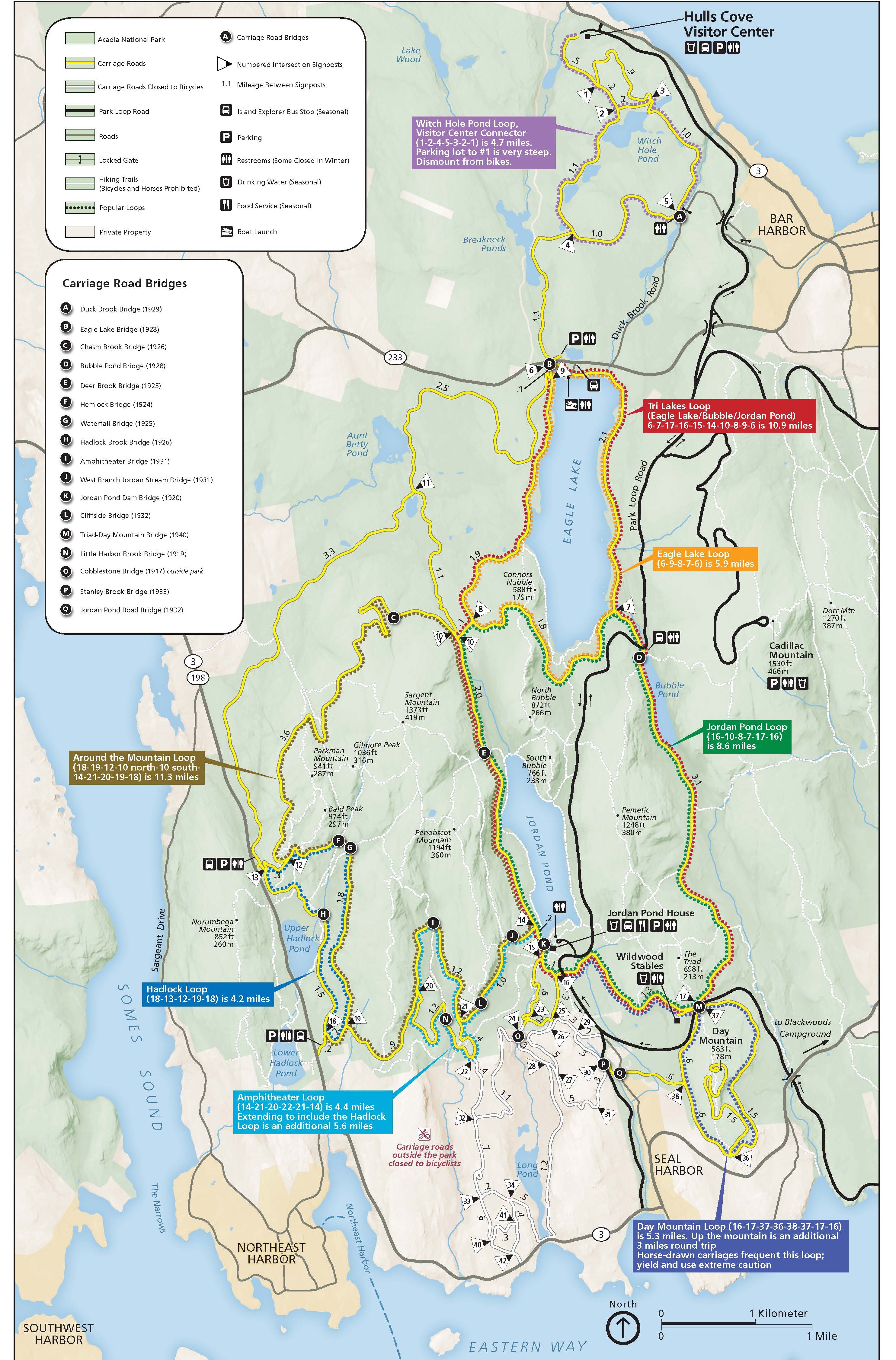
We spent the rest of the morning riding our bikes on the carriage roads inside the park. Instead of riding our bikes from the campground to the carriage roads, we decided to drive our van over to the parking lot of Jordan Pond House and ride from there. Our house batteries in our van were getting low on charge since our campsite was in full shade. So parking in the sun for the day sounded like a good idea. Plus we didn’t really want to ride our bikes on the park roads.

The carriage roads are well marked at all of the intersections and there is a nice printed map to follow. We had picked ours up at the visitor center when we arrived on Sunday. There was a sign on the carriage road near the park road that also had maps to take.

We originally thought about riding the Tri Lakes Loop. But then we found out that there is construction along the carriage road on the east side of Eagle Lake so it was closed. However, we did most of the route. Instead of just riding along the west side of Eagle Lake and coming back the same road to avoid the closure on the east side, we took a different carriage road over to Aunt Betty Pond and came back on the west side of Eagle Lake, making a loop. At the north end of Eagle Lake, we stopped to have a snack. The view was nice out across the lake, but it was rather noisy, not only from the construction on the east side, but also from the traffic on the nearby road.

The carriage roads are wonderful. They are gravel roads, nice and wide and smooth. Most of the time they are in the woods, with views out across the lakes and ponds every now and then. The carriage roads are not flat, but not very steep either. They rolled up and down for nice variety. There were only a couple of stretches where we seemed like we were climbing uphill for a good stretch.

Near the end of our bike ride, we came across the Jordan Pond Gate Lodge, right where the carriage road crossed over the Park Loop Road. The lodge, also known as the Gate House, was built in 1932.

Our total ride for the day was 15.6 miles with an elevation gain of 1312 feet in three hours and fifteen minutes.

It was lunch time when arrived back at the Jordan Pond House. The restaurant there is known for their popovers. However, there was a two hour wait to get a table. The information desk said there was carry out food in the gift shop. So we waited in line to go into the gift shop, only to find a pitiful selection of cold cut sandwiches. We opted to make sandwiches back in our Red Tail Lodge, what we call our van. Have we mentioned how we like having everything with us in our camper van?

We decided to do the touristy thing and put our name in for a table in the restaurant. And yes, it was about a two hour wait. The two hours gave us plenty of time to eat our sandwiches in our camper van, walk down to the lake to take in the view, and sit on the observation deck to just chill in the sunshine. We had nothing else planned for the day, so we just relaxed.

When we finally were seated, we opted for the two popovers and a drink each. The popovers come with butter and strawberry preserves. Left Buddy (LB) had a coffee while Right Buddy (RB) chose the blueberry lemonade. It was all very tasty. Expensive, but tasty.

From Jordan Pond, we drove the rest of the Park Loop Road that we had not seen yet, then continued back down past Sand Beach, cuz, why not? Our batteries still needed more charging, so enjoying the scenic drive seemed perfect. We turned off of the Park Loop Road onto Otter Cliff Road to get over to route 3, since we had not been on that road yet. It was dinner time when we reached the campground. It seems like eating was the theme of the day.

Wednesday we went for a long hike to Cadillac Mountain. From the campground, we took the 9:30 am shuttle bus to Sieur de Monts. From there we hiked along the west side of The Tarn to reach the start of the Ladder Trail. The shoreline along the Tarn was rocky.

A cormorant was drying his wings in the morning sun just a few feet from the trail. He did not seem bothered by our presence and let us pass by with hardly a flinch.

The Ladder Trail is steep. Most of the trail is stone steps, so the footing is pretty good. There are a few ladders and a couple of places with metal rungs to help you get through a few tricky sections. Be careful on the first ladder to not have your fingers wrapped around the rungs of the ladder, because it moves when you step on it. The ladder might crush you finger if they are underneath.

Then there is one place where you squeeze through a crack between two giant boulders. Our bodies fit through fine, it was our large packs that scraped the sides. RB had the bright idea to remove the water bottles from her pack which were sticking out the sides once she was wedged in. However, she could not reach them and just had to power through, scraping the pack along the rock.

After joining up with the Schiff Trail, there is a short spur to reach the Dorr Mountain summit. From the summit, there were nice views to the west towards Cadillac Mountain. Dorr Mountain is shorter than Cadillac Mountain, the summit is 1270 feet compared to Cadillac’s 1530 feet of elevation. There were only a handful of hikers at Dorr’s summit. We sat down and ate a small snack while enjoying the views of Cadillac Mountain.

The trail from Dorr summit over to Cadillac Mountain is steep and mostly through a boulder field. There were crowds of people on the top of Cadillac Mountain. When we reached the top, we couldn’t really determine where the actual summit was. The top is pretty flat. There is a large parking area for the people who purchased a pass to drive up, along with restrooms, a water refill station, and a gift shop.

We found a nice rock to sit on and enjoy the rest of the food we brought with us. There are 360 degree panoramic views from the top of Cadillac Mountain, since it is the tallest mountain in the area. There was enough room at the top of the mountain that you could claim a small area to yourself without feeling trapped in a crowd of people. Before we set out again, we used the restrooms and water fill station.

From the top of Cadillac Mountain, we took the Cadillac South Ridge Trail all the way back to the campground. At the trailhead, we were still discussing where the actual summit of the mountain must be. Another hiker at the trailhead overheard us talking and pointed down to his feet, saying “The marker is right here”. Sure enough, there was the survey marker. You would think there would be a sign or something indicating where it was. We were just a few feet from it and didn’t notice it.

The South Ridge Trail is a much more manageable trail than the trails we were on before, the slope is more gradual, although there are a few small steep sections. The trail stays exposed on the top of the rocky ridge for several miles. But that just means you have wonderful views laid out in front of you as you head toward the ocean.

The trail even gets easier once it heads back into the woods. However, it had been a long day of hiking and we were ready to be done. Even after crossing route 3, there is still almost a mile left to reach our campsite. The scenery is still beautiful, with trees shading the mossy green carpet that covers the rocks.

By the time we made it back to our campsite, we had covered 7.7 miles, clambering up a total of 1834 feet of elevation gain in just over six hours. It was hike number 45 of our 52 Hike Challenge and hike number 21 of our National Park Series. It was a gorgeous and challenging hike, but we were ready for a day of rest.

We packed in a lot for our first four days in Acadia. It was definitely living up to our expectations and we were looking forward to what the rest of our time there would hold in store for us.
Check out our related video: Acadia National Park: Blackwoods, Maine
(RB)